You are here: Home > Network List > TA - USArray Transportable Network (new EarthScope stations) Stations List
> Station 757A Oxford, FL, USA > Earthquake Result Viewer
757A Oxford, FL, USA - Earthquake Result Viewer
| Earthquake location: |
Kuril Islands |
| Earthquake latitude/longitude: |
51.0/157.3 |
| Earthquake time(UTC): |
2013/02/28 (059) 14:05:50 GMT |
| Earthquake Depth: |
41 km |
| Earthquake Magnitude: |
6.4 MB, 6.7 MS, 6.9 MW, 6.8 MW |
| Earthquake Catalog/Contributor: |
WHDF/NEIC |
|
| Network: |
TA USArray Transportable Network (new EarthScope stations) |
| Station: |
757A Oxford, FL, USA |
| Lat/Lon: |
28.94 N/82.07 W |
| Elevation: |
22 m |
|
| Distance: |
84.8 deg |
| Az: |
49.213 deg |
| Baz: |
326.881 deg |
| Ray Param: |
0.045145907 |
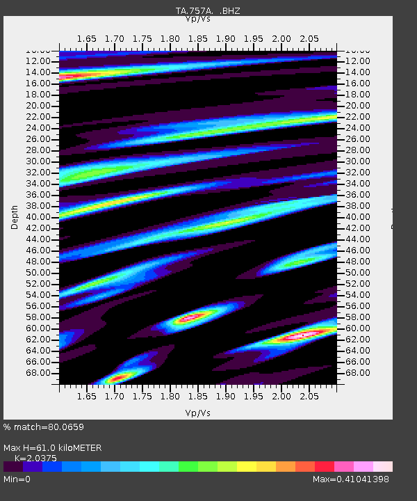
| Estimated Moho Depth: |
61.0 km |
| Estimated Crust Vp/Vs: |
2.04 |
| Assumed Crust Vp: |
5.989 km/s |
| Estimated Crust Vs: |
2.939 km/s |
| Estimated Crust Poisson's Ratio: |
0.34 |
|
| Radial Match: |
80.0659 % |
| Radial Bump: |
363 |
| Transverse Match: |
52.04385 % |
| Transverse Bump: |
400 |
| SOD ConfigId: |
494114 |
| Insert Time: |
2013-05-15 05:23:23.655 +0000 |
| GWidth: |
2.5 |
| Max Bumps: |
400 |
| Tol: |
0.001 |
|
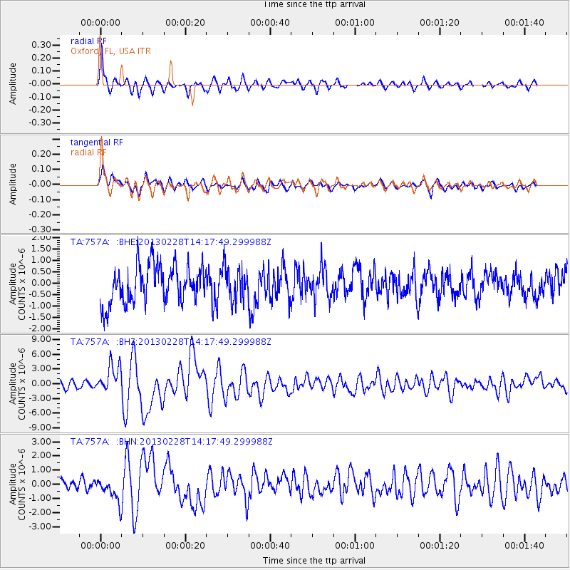
Signal To Noise
| Channel | StoN | STA | LTA |
| TA:757A: :BHZ:20130228T14:17:49.299988Z | 4.417373 | 2.9384923E-6 | 6.652126E-7 |
| TA:757A: :BHN:20130228T14:17:49.299988Z | 2.3025784 | 7.9772303E-7 | 3.464477E-7 |
| TA:757A: :BHE:20130228T14:17:49.299988Z | 0.8921157 | 7.3070106E-7 | 8.1906535E-7 |
| Arrivals |
| Ps | 11 SECOND |
| PpPs | 30 SECOND |
| PsPs/PpSs | 41 SECOND |


