You are here: Home > Network List > TA - USArray Transportable Network (new EarthScope stations) Stations List
> Station 554A Perry, FL, USA > Earthquake Result Viewer
554A Perry, FL, USA - Earthquake Result Viewer
| Earthquake location: |
Kuril Islands |
| Earthquake latitude/longitude: |
51.0/157.3 |
| Earthquake time(UTC): |
2013/02/28 (059) 14:05:50 GMT |
| Earthquake Depth: |
41 km |
| Earthquake Magnitude: |
6.4 MB, 6.7 MS, 6.9 MW, 6.8 MW |
| Earthquake Catalog/Contributor: |
WHDF/NEIC |
|
| Network: |
TA USArray Transportable Network (new EarthScope stations) |
| Station: |
554A Perry, FL, USA |
| Lat/Lon: |
30.08 N/83.68 W |
| Elevation: |
12 m |
|
| Distance: |
83.1 deg |
| Az: |
49.762 deg |
| Baz: |
326.148 deg |
| Ray Param: |
0.04636939 |
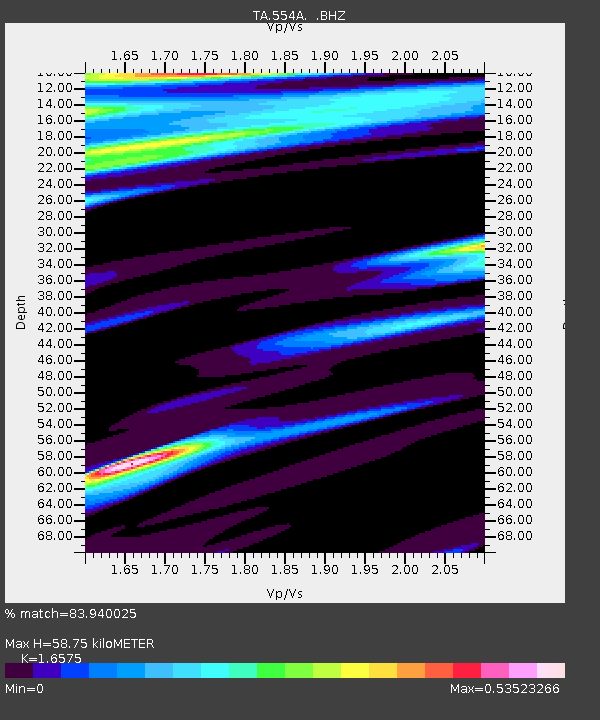
| Estimated Moho Depth: |
58.75 km |
| Estimated Crust Vp/Vs: |
1.66 |
| Assumed Crust Vp: |
6.565 km/s |
| Estimated Crust Vs: |
3.96 km/s |
| Estimated Crust Poisson's Ratio: |
0.21 |
|
| Radial Match: |
83.940025 % |
| Radial Bump: |
358 |
| Transverse Match: |
71.388885 % |
| Transverse Bump: |
400 |
| SOD ConfigId: |
494114 |
| Insert Time: |
2013-05-15 05:23:34.964 +0000 |
| GWidth: |
2.5 |
| Max Bumps: |
400 |
| Tol: |
0.001 |
|

Signal To Noise
| Channel | StoN | STA | LTA |
| TA:554A: :BHZ:20130228T14:17:40.525024Z | 5.3656354 | 3.7761627E-6 | 7.03768E-7 |
| TA:554A: :BHN:20130228T14:17:40.525024Z | 2.5218322 | 9.987554E-7 | 3.960435E-7 |
| TA:554A: :BHE:20130228T14:17:40.525024Z | 0.6841722 | 4.086448E-7 | 5.9728353E-7 |
| Arrivals |
| Ps | 6.1 SECOND |
| PpPs | 23 SECOND |
| PsPs/PpSs | 29 SECOND |


