You are here: Home > Network List > TA - USArray Transportable Network (new EarthScope stations) Stations List
> Station 957A Wimauma, FL, USA > Earthquake Result Viewer
957A Wimauma, FL, USA - Earthquake Result Viewer
| Earthquake location: |
Kuril Islands |
| Earthquake latitude/longitude: |
51.0/157.3 |
| Earthquake time(UTC): |
2013/02/28 (059) 14:05:50 GMT |
| Earthquake Depth: |
41 km |
| Earthquake Magnitude: |
6.4 MB, 6.7 MS, 6.9 MW, 6.8 MW |
| Earthquake Catalog/Contributor: |
WHDF/NEIC |
|
| Network: |
TA USArray Transportable Network (new EarthScope stations) |
| Station: |
957A Wimauma, FL, USA |
| Lat/Lon: |
27.67 N/82.24 W |
| Elevation: |
35 m |
|
| Distance: |
85.8 deg |
| Az: |
50.031 deg |
| Baz: |
326.869 deg |
| Ray Param: |
0.0444439 |
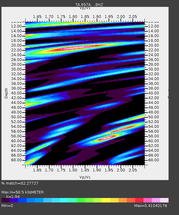
| Estimated Moho Depth: |
58.5 km |
| Estimated Crust Vp/Vs: |
1.94 |
| Assumed Crust Vp: |
5.845 km/s |
| Estimated Crust Vs: |
3.013 km/s |
| Estimated Crust Poisson's Ratio: |
0.32 |
|
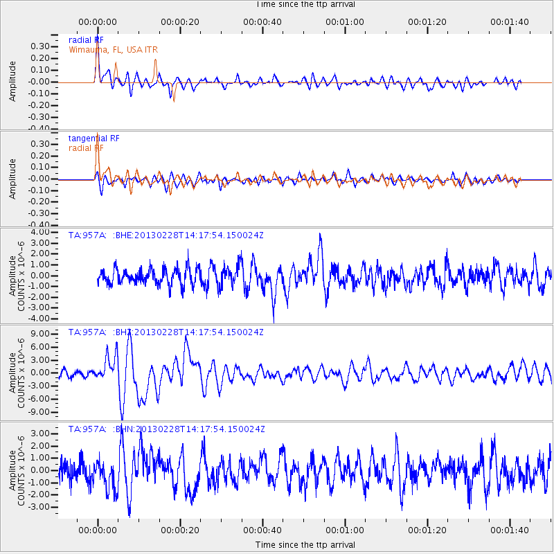
| Radial Match: |
82.27727 % |
| Radial Bump: |
400 |
| Transverse Match: |
58.299053 % |
| Transverse Bump: |
400 |
| SOD ConfigId: |
494114 |
| Insert Time: |
2013-05-15 05:23:58.310 +0000 |
| GWidth: |
2.5 |
| Max Bumps: |
400 |
| Tol: |
0.001 |
|
Signal To Noise
| Channel | StoN | STA | LTA |
| TA:957A: :BHZ:20130228T14:17:54.150024Z | 4.8495655 | 3.0888525E-6 | 6.369339E-7 |
| TA:957A: :BHN:20130228T14:17:54.150024Z | 1.868638 | 1.1802551E-6 | 6.316125E-7 |
| TA:957A: :BHE:20130228T14:17:54.150024Z | 1.3725821 | 9.772642E-7 | 7.119896E-7 |
| Arrivals |
| Ps | 9.6 SECOND |
| PpPs | 29 SECOND |
| PsPs/PpSs | 38 SECOND |


