You are here: Home > Network List > TA - USArray Transportable Network (new EarthScope stations) Stations List
> Station 254A Abbeville, GA, USA > Earthquake Result Viewer
254A Abbeville, GA, USA - Earthquake Result Viewer
| Earthquake location: |
Kuril Islands |
| Earthquake latitude/longitude: |
51.0/157.3 |
| Earthquake time(UTC): |
2013/02/28 (059) 14:05:50 GMT |
| Earthquake Depth: |
41 km |
| Earthquake Magnitude: |
6.4 MB, 6.7 MS, 6.9 MW, 6.8 MW |
| Earthquake Catalog/Contributor: |
WHDF/NEIC |
|
| Network: |
TA USArray Transportable Network (new EarthScope stations) |
| Station: |
254A Abbeville, GA, USA |
| Lat/Lon: |
31.95 N/83.29 W |
| Elevation: |
78 m |
|
| Distance: |
81.7 deg |
| Az: |
48.437 deg |
| Baz: |
326.174 deg |
| Ray Param: |
0.047309875 |
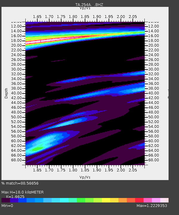
| Estimated Moho Depth: |
18.0 km |
| Estimated Crust Vp/Vs: |
1.66 |
| Assumed Crust Vp: |
6.565 km/s |
| Estimated Crust Vs: |
3.949 km/s |
| Estimated Crust Poisson's Ratio: |
0.22 |
|
| Radial Match: |
88.56656 % |
| Radial Bump: |
346 |
| Transverse Match: |
80.283 % |
| Transverse Bump: |
400 |
| SOD ConfigId: |
494114 |
| Insert Time: |
2013-05-15 05:24:43.574 +0000 |
| GWidth: |
2.5 |
| Max Bumps: |
400 |
| Tol: |
0.001 |
|
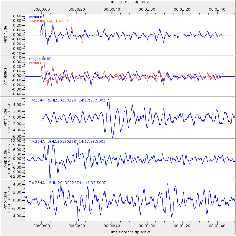
Signal To Noise
| Channel | StoN | STA | LTA |
| TA:254A: :BHZ:20130228T14:17:33.500Z | 13.673316 | 5.1662164E-6 | 3.77832E-7 |
| TA:254A: :BHN:20130228T14:17:33.500Z | 1.3401326 | 9.542467E-7 | 7.12054E-7 |
| TA:254A: :BHE:20130228T14:17:33.500Z | 1.0504918 | 9.77339E-7 | 9.303632E-7 |
| Arrivals |
| Ps | 1.9 SECOND |
| PpPs | 7.1 SECOND |
| PsPs/PpSs | 9.0 SECOND |


