You are here: Home > Network List > TA - USArray Transportable Network (new EarthScope stations) Stations List
> Station 155A Kite, GA, USA > Earthquake Result Viewer
155A Kite, GA, USA - Earthquake Result Viewer
| Earthquake location: |
Kuril Islands |
| Earthquake latitude/longitude: |
51.0/157.3 |
| Earthquake time(UTC): |
2013/02/28 (059) 14:05:50 GMT |
| Earthquake Depth: |
41 km |
| Earthquake Magnitude: |
6.4 MB, 6.7 MS, 6.9 MW, 6.8 MW |
| Earthquake Catalog/Contributor: |
WHDF/NEIC |
|
| Network: |
TA USArray Transportable Network (new EarthScope stations) |
| Station: |
155A Kite, GA, USA |
| Lat/Lon: |
32.62 N/82.47 W |
| Elevation: |
93 m |
|
| Distance: |
81.6 deg |
| Az: |
47.472 deg |
| Baz: |
326.472 deg |
| Ray Param: |
0.04743201 |
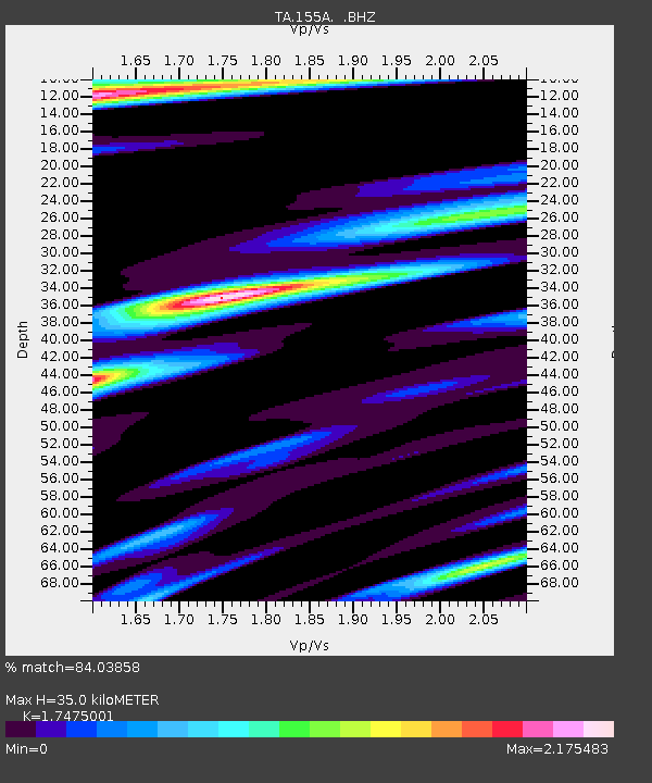
| Estimated Moho Depth: |
35.0 km |
| Estimated Crust Vp/Vs: |
1.75 |
| Assumed Crust Vp: |
6.565 km/s |
| Estimated Crust Vs: |
3.757 km/s |
| Estimated Crust Poisson's Ratio: |
0.26 |
|
| Radial Match: |
84.03858 % |
| Radial Bump: |
367 |
| Transverse Match: |
85.751915 % |
| Transverse Bump: |
399 |
| SOD ConfigId: |
494114 |
| Insert Time: |
2013-05-15 05:25:07.940 +0000 |
| GWidth: |
2.5 |
| Max Bumps: |
400 |
| Tol: |
0.001 |
|
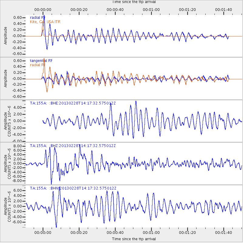
Signal To Noise
| Channel | StoN | STA | LTA |
| TA:155A: :BHZ:20130228T14:17:32.575012Z | 12.385895 | 4.047385E-6 | 3.2677374E-7 |
| TA:155A: :BHN:20130228T14:17:32.575012Z | 1.4432182 | 1.081412E-6 | 7.49306E-7 |
| TA:155A: :BHE:20130228T14:17:32.575012Z | 0.966116 | 1.0312258E-6 | 1.0673933E-6 |
| Arrivals |
| Ps | 4.1 SECOND |
| PpPs | 14 SECOND |
| PsPs/PpSs | 18 SECOND |


