You are here: Home > Network List > TA - USArray Transportable Network (new EarthScope stations) Stations List
> Station X51A Calhoun, GA, USA > Earthquake Result Viewer
X51A Calhoun, GA, USA - Earthquake Result Viewer
| Earthquake location: |
Kuril Islands |
| Earthquake latitude/longitude: |
51.0/157.3 |
| Earthquake time(UTC): |
2013/02/28 (059) 14:05:50 GMT |
| Earthquake Depth: |
41 km |
| Earthquake Magnitude: |
6.4 MB, 6.7 MS, 6.9 MW, 6.8 MW |
| Earthquake Catalog/Contributor: |
WHDF/NEIC |
|
| Network: |
TA USArray Transportable Network (new EarthScope stations) |
| Station: |
X51A Calhoun, GA, USA |
| Lat/Lon: |
34.57 N/84.86 W |
| Elevation: |
214 m |
|
| Distance: |
78.8 deg |
| Az: |
48.044 deg |
| Baz: |
325.252 deg |
| Ray Param: |
0.04930293 |
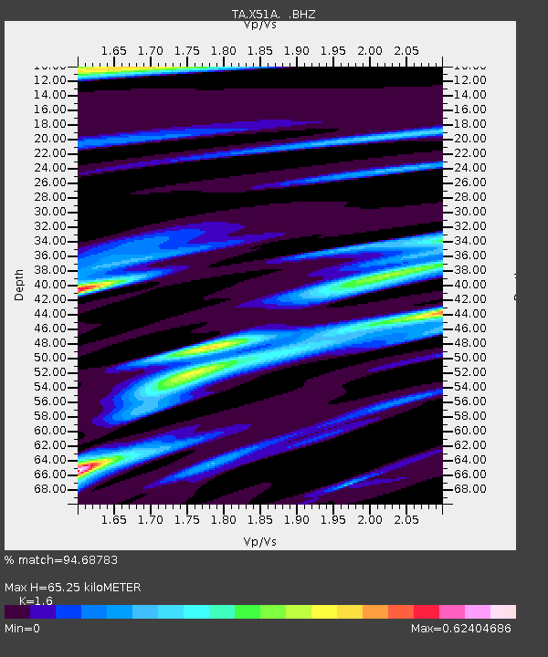
| Estimated Moho Depth: |
65.25 km |
| Estimated Crust Vp/Vs: |
1.60 |
| Assumed Crust Vp: |
6.35 km/s |
| Estimated Crust Vs: |
3.969 km/s |
| Estimated Crust Poisson's Ratio: |
0.18 |
|
| Radial Match: |
94.68783 % |
| Radial Bump: |
290 |
| Transverse Match: |
72.01897 % |
| Transverse Bump: |
400 |
| SOD ConfigId: |
494114 |
| Insert Time: |
2013-05-15 05:25:30.183 +0000 |
| GWidth: |
2.5 |
| Max Bumps: |
400 |
| Tol: |
0.001 |
|

Signal To Noise
| Channel | StoN | STA | LTA |
| TA:X51A: :BHZ:20130228T14:17:17.974976Z | 8.262975 | 3.7031277E-6 | 4.4815917E-7 |
| TA:X51A: :BHN:20130228T14:17:17.974976Z | 4.3415804 | 1.0521721E-6 | 2.4234774E-7 |
| TA:X51A: :BHE:20130228T14:17:17.974976Z | 2.6845698 | 9.0299363E-7 | 3.3636437E-7 |
| Arrivals |
| Ps | 6.4 SECOND |
| PpPs | 26 SECOND |
| PsPs/PpSs | 32 SECOND |


