You are here: Home > Network List > TA - USArray Transportable Network (new EarthScope stations) Stations List
> Station Z51A Franklin, GA, USA > Earthquake Result Viewer
Z51A Franklin, GA, USA - Earthquake Result Viewer
| Earthquake location: |
Kuril Islands |
| Earthquake latitude/longitude: |
51.0/157.3 |
| Earthquake time(UTC): |
2013/02/28 (059) 14:05:50 GMT |
| Earthquake Depth: |
41 km |
| Earthquake Magnitude: |
6.4 MB, 6.7 MS, 6.9 MW, 6.8 MW |
| Earthquake Catalog/Contributor: |
WHDF/NEIC |
|
| Network: |
TA USArray Transportable Network (new EarthScope stations) |
| Station: |
Z51A Franklin, GA, USA |
| Lat/Lon: |
33.32 N/85.17 W |
| Elevation: |
249 m |
|
| Distance: |
79.7 deg |
| Az: |
48.987 deg |
| Baz: |
325.252 deg |
| Ray Param: |
0.048706025 |
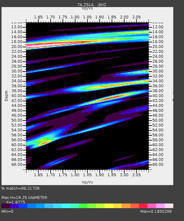
| Estimated Moho Depth: |
19.25 km |
| Estimated Crust Vp/Vs: |
1.68 |
| Assumed Crust Vp: |
6.719 km/s |
| Estimated Crust Vs: |
4.006 km/s |
| Estimated Crust Poisson's Ratio: |
0.22 |
|
| Radial Match: |
86.21709 % |
| Radial Bump: |
400 |
| Transverse Match: |
64.008385 % |
| Transverse Bump: |
400 |
| SOD ConfigId: |
494114 |
| Insert Time: |
2013-05-15 05:25:43.901 +0000 |
| GWidth: |
2.5 |
| Max Bumps: |
400 |
| Tol: |
0.001 |
|
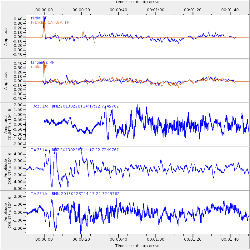
Signal To Noise
| Channel | StoN | STA | LTA |
| TA:Z51A: :BHZ:20130228T14:17:22.724976Z | 12.578236 | 3.0114786E-6 | 2.3941982E-7 |
| TA:Z51A: :BHN:20130228T14:17:22.724976Z | 3.4203055 | 8.396646E-7 | 2.4549405E-7 |
| TA:Z51A: :BHE:20130228T14:17:22.724976Z | 1.9559612 | 8.6040126E-7 | 4.3988663E-7 |
| Arrivals |
| Ps | 2.0 SECOND |
| PpPs | 7.4 SECOND |
| PsPs/PpSs | 9.4 SECOND |


