You are here: Home > Network List > TA - USArray Transportable Network (new EarthScope stations) Stations List
> Station X53A Estanollee, GA, USA > Earthquake Result Viewer
X53A Estanollee, GA, USA - Earthquake Result Viewer
| Earthquake location: |
Kuril Islands |
| Earthquake latitude/longitude: |
51.0/157.3 |
| Earthquake time(UTC): |
2013/02/28 (059) 14:05:50 GMT |
| Earthquake Depth: |
41 km |
| Earthquake Magnitude: |
6.4 MB, 6.7 MS, 6.9 MW, 6.8 MW |
| Earthquake Catalog/Contributor: |
WHDF/NEIC |
|
| Network: |
TA USArray Transportable Network (new EarthScope stations) |
| Station: |
X53A Estanollee, GA, USA |
| Lat/Lon: |
34.50 N/83.30 W |
| Elevation: |
240 m |
|
| Distance: |
79.6 deg |
| Az: |
47.001 deg |
| Baz: |
325.936 deg |
| Ray Param: |
0.04877162 |
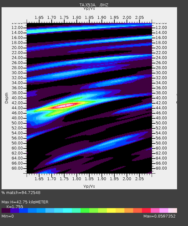
| Estimated Moho Depth: |
42.75 km |
| Estimated Crust Vp/Vs: |
1.75 |
| Assumed Crust Vp: |
6.35 km/s |
| Estimated Crust Vs: |
3.618 km/s |
| Estimated Crust Poisson's Ratio: |
0.26 |
|
| Radial Match: |
94.72548 % |
| Radial Bump: |
269 |
| Transverse Match: |
72.20052 % |
| Transverse Bump: |
400 |
| SOD ConfigId: |
494114 |
| Insert Time: |
2013-05-15 05:26:03.422 +0000 |
| GWidth: |
2.5 |
| Max Bumps: |
400 |
| Tol: |
0.001 |
|
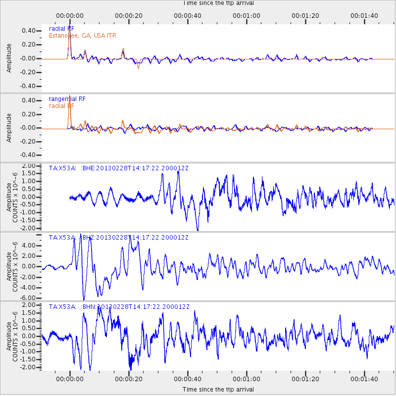
Signal To Noise
| Channel | StoN | STA | LTA |
| TA:X53A: :BHZ:20130228T14:17:22.200012Z | 8.123298 | 3.2824526E-6 | 4.040788E-7 |
| TA:X53A: :BHN:20130228T14:17:22.200012Z | 5.1895127 | 9.609327E-7 | 1.8516819E-7 |
| TA:X53A: :BHE:20130228T14:17:22.200012Z | 2.7936287 | 6.857601E-7 | 2.4547288E-7 |
| Arrivals |
| Ps | 5.2 SECOND |
| PpPs | 18 SECOND |
| PsPs/PpSs | 23 SECOND |


