You are here: Home > Network List > TA - USArray Transportable Network (new EarthScope stations) Stations List
> Station W52A Murphy, NC, USA > Earthquake Result Viewer
W52A Murphy, NC, USA - Earthquake Result Viewer
| Earthquake location: |
Kuril Islands |
| Earthquake latitude/longitude: |
51.0/157.3 |
| Earthquake time(UTC): |
2013/02/28 (059) 14:05:50 GMT |
| Earthquake Depth: |
41 km |
| Earthquake Magnitude: |
6.4 MB, 6.7 MS, 6.9 MW, 6.8 MW |
| Earthquake Catalog/Contributor: |
WHDF/NEIC |
|
| Network: |
TA USArray Transportable Network (new EarthScope stations) |
| Station: |
W52A Murphy, NC, USA |
| Lat/Lon: |
35.09 N/83.93 W |
| Elevation: |
519 m |
|
| Distance: |
78.8 deg |
| Az: |
47.098 deg |
| Baz: |
325.598 deg |
| Ray Param: |
0.049302556 |
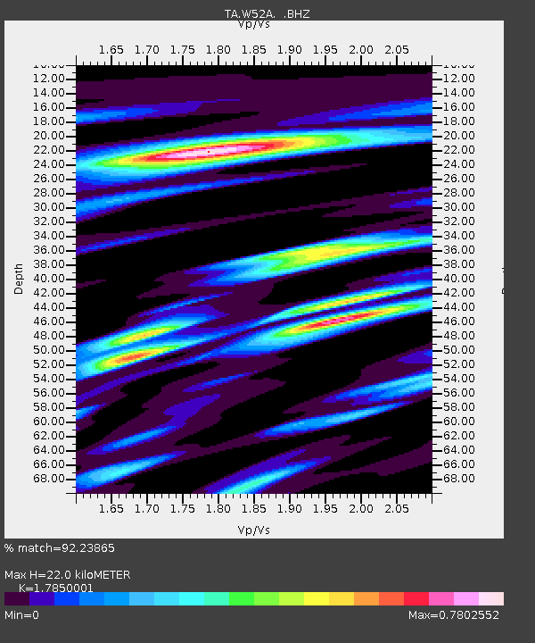
| Estimated Moho Depth: |
22.0 km |
| Estimated Crust Vp/Vs: |
1.79 |
| Assumed Crust Vp: |
6.35 km/s |
| Estimated Crust Vs: |
3.557 km/s |
| Estimated Crust Poisson's Ratio: |
0.27 |
|
| Radial Match: |
92.23865 % |
| Radial Bump: |
355 |
| Transverse Match: |
76.47842 % |
| Transverse Bump: |
400 |
| SOD ConfigId: |
494114 |
| Insert Time: |
2013-05-15 05:26:25.459 +0000 |
| GWidth: |
2.5 |
| Max Bumps: |
400 |
| Tol: |
0.001 |
|

Signal To Noise
| Channel | StoN | STA | LTA |
| TA:W52A: :BHZ:20130228T14:17:17.974976Z | 6.912753 | 2.6492603E-6 | 3.8324242E-7 |
| TA:W52A: :BHN:20130228T14:17:17.974976Z | 2.728977 | 9.6937E-7 | 3.5521373E-7 |
| TA:W52A: :BHE:20130228T14:17:17.974976Z | 1.7494893 | 6.151977E-7 | 3.5164413E-7 |
| Arrivals |
| Ps | 2.8 SECOND |
| PpPs | 9.4 SECOND |
| PsPs/PpSs | 12 SECOND |


