You are here: Home > Network List > TA - USArray Transportable Network (new EarthScope stations) Stations List
> Station V51A Loudon, TN, USA > Earthquake Result Viewer
V51A Loudon, TN, USA - Earthquake Result Viewer
| Earthquake location: |
Kuril Islands |
| Earthquake latitude/longitude: |
51.0/157.3 |
| Earthquake time(UTC): |
2013/02/28 (059) 14:05:50 GMT |
| Earthquake Depth: |
41 km |
| Earthquake Magnitude: |
6.4 MB, 6.7 MS, 6.9 MW, 6.8 MW |
| Earthquake Catalog/Contributor: |
WHDF/NEIC |
|
| Network: |
TA USArray Transportable Network (new EarthScope stations) |
| Station: |
V51A Loudon, TN, USA |
| Lat/Lon: |
35.80 N/84.35 W |
| Elevation: |
243 m |
|
| Distance: |
78.1 deg |
| Az: |
46.979 deg |
| Baz: |
325.33 deg |
| Ray Param: |
0.04983088 |
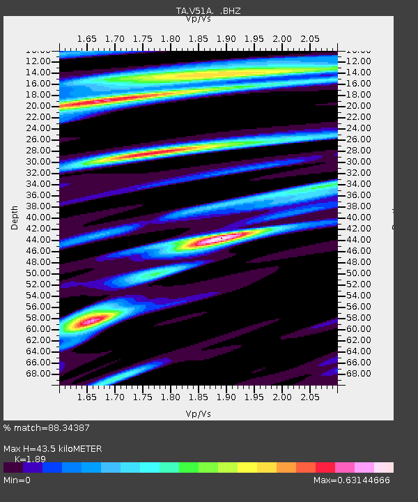
| Estimated Moho Depth: |
43.5 km |
| Estimated Crust Vp/Vs: |
1.89 |
| Assumed Crust Vp: |
6.35 km/s |
| Estimated Crust Vs: |
3.36 km/s |
| Estimated Crust Poisson's Ratio: |
0.31 |
|
| Radial Match: |
88.34387 % |
| Radial Bump: |
348 |
| Transverse Match: |
75.05424 % |
| Transverse Bump: |
400 |
| SOD ConfigId: |
494114 |
| Insert Time: |
2013-05-15 05:26:52.519 +0000 |
| GWidth: |
2.5 |
| Max Bumps: |
400 |
| Tol: |
0.001 |
|

Signal To Noise
| Channel | StoN | STA | LTA |
| TA:V51A: :BHZ:20130228T14:17:13.674988Z | 6.980854 | 2.7284157E-6 | 3.9084267E-7 |
| TA:V51A: :BHN:20130228T14:17:13.674988Z | 3.3063927 | 8.123201E-7 | 2.456817E-7 |
| TA:V51A: :BHE:20130228T14:17:13.674988Z | 2.8384836 | 6.693322E-7 | 2.3580627E-7 |
| Arrivals |
| Ps | 6.3 SECOND |
| PpPs | 19 SECOND |
| PsPs/PpSs | 26 SECOND |


