You are here: Home > Network List > CB - China National Seismic Network Stations List
> Station DL2 Dalian,Liaoning Province > Earthquake Result Viewer
DL2 Dalian,Liaoning Province - Earthquake Result Viewer
| Earthquake location: |
Northern Sumatra, Indonesia |
| Earthquake latitude/longitude: |
2.0/97.0 |
| Earthquake time(UTC): |
2014/07/05 (186) 09:39:30 GMT |
| Earthquake Depth: |
30 km |
| Earthquake Magnitude: |
6.0 MWB |
| Earthquake Catalog/Contributor: |
NEIC PDE/NEIC COMCAT |
|
| Network: |
CB China National Seismic Network |
| Station: |
DL2 Dalian,Liaoning Province |
| Lat/Lon: |
38.91 N/121.63 E |
| Elevation: |
65 m |
|
| Distance: |
43.1 deg |
| Az: |
28.416 deg |
| Baz: |
217.557 deg |
| Ray Param: |
0.07273198 |
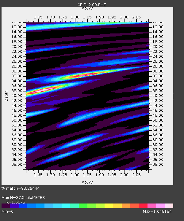
| Estimated Moho Depth: |
37.5 km |
| Estimated Crust Vp/Vs: |
1.67 |
| Assumed Crust Vp: |
6.134 km/s |
| Estimated Crust Vs: |
3.678 km/s |
| Estimated Crust Poisson's Ratio: |
0.22 |
|
| Radial Match: |
93.26444 % |
| Radial Bump: |
385 |
| Transverse Match: |
80.17333 % |
| Transverse Bump: |
400 |
| SOD ConfigId: |
3390531 |
| Insert Time: |
2019-04-12 17:19:06.651 +0000 |
| GWidth: |
2.5 |
| Max Bumps: |
400 |
| Tol: |
0.001 |
|

Signal To Noise
| Channel | StoN | STA | LTA |
| CB:DL2:00:BHZ:20140705T09:46:56.169995Z | 24.754566 | 3.6046706E-6 | 1.4561638E-7 |
| CB:DL2:00:BHN:20140705T09:46:56.169995Z | 15.781391 | 1.7869154E-6 | 1.1322927E-7 |
| CB:DL2:00:BHE:20140705T09:46:56.169995Z | 10.957514 | 1.2396264E-6 | 1.1313027E-7 |
| Arrivals |
| Ps | 4.4 SECOND |
| PpPs | 15 SECOND |
| PsPs/PpSs | 20 SECOND |


