You are here: Home > Network List > CB - China National Seismic Network Stations List
> Station HHC Huhehaote,Neimeng Province > Earthquake Result Viewer
HHC Huhehaote,Neimeng Province - Earthquake Result Viewer
| Earthquake location: |
Northern Sumatra, Indonesia |
| Earthquake latitude/longitude: |
2.0/97.0 |
| Earthquake time(UTC): |
2014/07/05 (186) 09:39:30 GMT |
| Earthquake Depth: |
30 km |
| Earthquake Magnitude: |
6.0 MWB |
| Earthquake Catalog/Contributor: |
NEIC PDE/NEIC COMCAT |
|
| Network: |
CB China National Seismic Network |
| Station: |
HHC Huhehaote,Neimeng Province |
| Lat/Lon: |
40.85 N/111.56 E |
| Elevation: |
1169 m |
|
| Distance: |
40.9 deg |
| Az: |
16.936 deg |
| Baz: |
202.568 deg |
| Ray Param: |
0.07409665 |
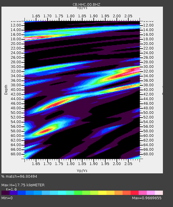
| Estimated Moho Depth: |
17.75 km |
| Estimated Crust Vp/Vs: |
1.60 |
| Assumed Crust Vp: |
6.384 km/s |
| Estimated Crust Vs: |
3.99 km/s |
| Estimated Crust Poisson's Ratio: |
0.18 |
|
| Radial Match: |
96.80494 % |
| Radial Bump: |
335 |
| Transverse Match: |
69.43158 % |
| Transverse Bump: |
400 |
| SOD ConfigId: |
3390531 |
| Insert Time: |
2019-04-12 17:19:07.001 +0000 |
| GWidth: |
2.5 |
| Max Bumps: |
400 |
| Tol: |
0.001 |
|

Signal To Noise
| Channel | StoN | STA | LTA |
| CB:HHC:00:BHZ:20140705T09:46:38.069989Z | 8.858525 | 2.325933E-6 | 2.6256438E-7 |
| CB:HHC:00:BHN:20140705T09:46:38.069989Z | 4.572418 | 1.4897145E-6 | 3.2580454E-7 |
| CB:HHC:00:BHE:20140705T09:46:38.069989Z | 1.8864788 | 5.768602E-7 | 3.0578673E-7 |
| Arrivals |
| Ps | 1.8 SECOND |
| PpPs | 6.7 SECOND |
| PsPs/PpSs | 8.5 SECOND |


