You are here: Home > Network List > TA - USArray Transportable Network (new EarthScope stations) Stations List
> Station V52A Sevierville, TN, USA > Earthquake Result Viewer
V52A Sevierville, TN, USA - Earthquake Result Viewer
| Earthquake location: |
Kuril Islands |
| Earthquake latitude/longitude: |
51.0/157.3 |
| Earthquake time(UTC): |
2013/02/28 (059) 14:05:50 GMT |
| Earthquake Depth: |
41 km |
| Earthquake Magnitude: |
6.4 MB, 6.7 MS, 6.9 MW, 6.8 MW |
| Earthquake Catalog/Contributor: |
WHDF/NEIC |
|
| Network: |
TA USArray Transportable Network (new EarthScope stations) |
| Station: |
V52A Sevierville, TN, USA |
| Lat/Lon: |
35.84 N/83.60 W |
| Elevation: |
328 m |
|
| Distance: |
78.4 deg |
| Az: |
46.44 deg |
| Baz: |
325.66 deg |
| Ray Param: |
0.04961589 |
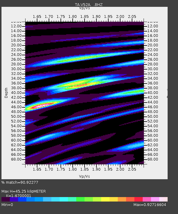
| Estimated Moho Depth: |
45.25 km |
| Estimated Crust Vp/Vs: |
1.67 |
| Assumed Crust Vp: |
6.35 km/s |
| Estimated Crust Vs: |
3.802 km/s |
| Estimated Crust Poisson's Ratio: |
0.22 |
|
| Radial Match: |
90.92277 % |
| Radial Bump: |
400 |
| Transverse Match: |
79.998055 % |
| Transverse Bump: |
400 |
| SOD ConfigId: |
494114 |
| Insert Time: |
2013-05-15 05:27:11.871 +0000 |
| GWidth: |
2.5 |
| Max Bumps: |
400 |
| Tol: |
0.001 |
|

Signal To Noise
| Channel | StoN | STA | LTA |
| TA:V52A: :BHZ:20130228T14:17:15.424988Z | 11.194113 | 3.12632E-6 | 2.7928252E-7 |
| TA:V52A: :BHN:20130228T14:17:15.424988Z | 3.5017426 | 1.0260528E-6 | 2.9301208E-7 |
| TA:V52A: :BHE:20130228T14:17:15.424988Z | 3.2876925 | 8.3733846E-7 | 2.5468879E-7 |
| Arrivals |
| Ps | 4.9 SECOND |
| PpPs | 18 SECOND |
| PsPs/PpSs | 23 SECOND |


