You are here: Home > Network List > TA - USArray Transportable Network (new EarthScope stations) Stations List
> Station V53A Saluda, NC, USA > Earthquake Result Viewer
V53A Saluda, NC, USA - Earthquake Result Viewer
| Earthquake location: |
Kuril Islands |
| Earthquake latitude/longitude: |
51.0/157.3 |
| Earthquake time(UTC): |
2013/02/28 (059) 14:05:50 GMT |
| Earthquake Depth: |
41 km |
| Earthquake Magnitude: |
6.4 MB, 6.7 MS, 6.9 MW, 6.8 MW |
| Earthquake Catalog/Contributor: |
WHDF/NEIC |
|
| Network: |
TA USArray Transportable Network (new EarthScope stations) |
| Station: |
V53A Saluda, NC, USA |
| Lat/Lon: |
35.67 N/82.81 W |
| Elevation: |
681 m |
|
| Distance: |
78.9 deg |
| Az: |
46.0 deg |
| Baz: |
326.029 deg |
| Ray Param: |
0.04927774 |
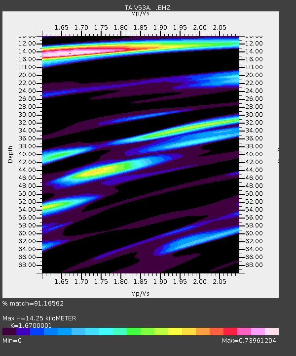
| Estimated Moho Depth: |
14.25 km |
| Estimated Crust Vp/Vs: |
1.67 |
| Assumed Crust Vp: |
6.35 km/s |
| Estimated Crust Vs: |
3.802 km/s |
| Estimated Crust Poisson's Ratio: |
0.22 |
|
| Radial Match: |
91.16562 % |
| Radial Bump: |
400 |
| Transverse Match: |
73.36757 % |
| Transverse Bump: |
400 |
| SOD ConfigId: |
494114 |
| Insert Time: |
2013-05-15 05:27:29.117 +0000 |
| GWidth: |
2.5 |
| Max Bumps: |
400 |
| Tol: |
0.001 |
|

Signal To Noise
| Channel | StoN | STA | LTA |
| TA:V53A: :BHZ:20130228T14:17:18.174988Z | 9.608068 | 2.4613478E-6 | 2.5617507E-7 |
| TA:V53A: :BHN:20130228T14:17:18.174988Z | 4.200535 | 7.4357723E-7 | 1.7701967E-7 |
| TA:V53A: :BHE:20130228T14:17:18.174988Z | 1.8707546 | 4.4196202E-7 | 2.3624798E-7 |
| Arrivals |
| Ps | 1.5 SECOND |
| PpPs | 5.8 SECOND |
| PsPs/PpSs | 7.4 SECOND |


