You are here: Home > Network List > TA - USArray Transportable Network (new EarthScope stations) Stations List
> Station S47A Hartford, KY, USA > Earthquake Result Viewer
S47A Hartford, KY, USA - Earthquake Result Viewer
| Earthquake location: |
Kuril Islands |
| Earthquake latitude/longitude: |
51.0/157.3 |
| Earthquake time(UTC): |
2013/02/28 (059) 14:05:50 GMT |
| Earthquake Depth: |
41 km |
| Earthquake Magnitude: |
6.4 MB, 6.7 MS, 6.9 MW, 6.8 MW |
| Earthquake Catalog/Contributor: |
WHDF/NEIC |
|
| Network: |
TA USArray Transportable Network (new EarthScope stations) |
| Station: |
S47A Hartford, KY, USA |
| Lat/Lon: |
37.59 N/86.88 W |
| Elevation: |
181 m |
|
| Distance: |
75.4 deg |
| Az: |
47.618 deg |
| Baz: |
323.972 deg |
| Ray Param: |
0.05160628 |
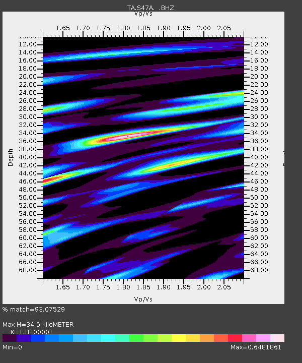
| Estimated Moho Depth: |
34.5 km |
| Estimated Crust Vp/Vs: |
1.81 |
| Assumed Crust Vp: |
6.444 km/s |
| Estimated Crust Vs: |
3.56 km/s |
| Estimated Crust Poisson's Ratio: |
0.28 |
|
| Radial Match: |
93.07529 % |
| Radial Bump: |
383 |
| Transverse Match: |
81.35932 % |
| Transverse Bump: |
400 |
| SOD ConfigId: |
494114 |
| Insert Time: |
2013-05-15 05:28:09.428 +0000 |
| GWidth: |
2.5 |
| Max Bumps: |
400 |
| Tol: |
0.001 |
|

Signal To Noise
| Channel | StoN | STA | LTA |
| TA:S47A: :BHZ:20130228T14:16:58.875Z | 19.730816 | 3.7253467E-6 | 1.8880854E-7 |
| TA:S47A: :BHN:20130228T14:16:58.875Z | 6.877954 | 1.5966465E-6 | 2.3213974E-7 |
| TA:S47A: :BHE:20130228T14:16:58.875Z | 5.186924 | 9.4772764E-7 | 1.8271477E-7 |
| Arrivals |
| Ps | 4.5 SECOND |
| PpPs | 15 SECOND |
| PsPs/PpSs | 19 SECOND |


