You are here: Home > Network List > TA - USArray Transportable Network (new EarthScope stations) Stations List
> Station R50A Paris, KY, USA > Earthquake Result Viewer
R50A Paris, KY, USA - Earthquake Result Viewer
| Earthquake location: |
Kuril Islands |
| Earthquake latitude/longitude: |
51.0/157.3 |
| Earthquake time(UTC): |
2013/02/28 (059) 14:05:50 GMT |
| Earthquake Depth: |
41 km |
| Earthquake Magnitude: |
6.4 MB, 6.7 MS, 6.9 MW, 6.8 MW |
| Earthquake Catalog/Contributor: |
WHDF/NEIC |
|
| Network: |
TA USArray Transportable Network (new EarthScope stations) |
| Station: |
R50A Paris, KY, USA |
| Lat/Lon: |
38.28 N/84.33 W |
| Elevation: |
255 m |
|
| Distance: |
76.0 deg |
| Az: |
45.513 deg |
| Baz: |
325.015 deg |
| Ray Param: |
0.051192522 |
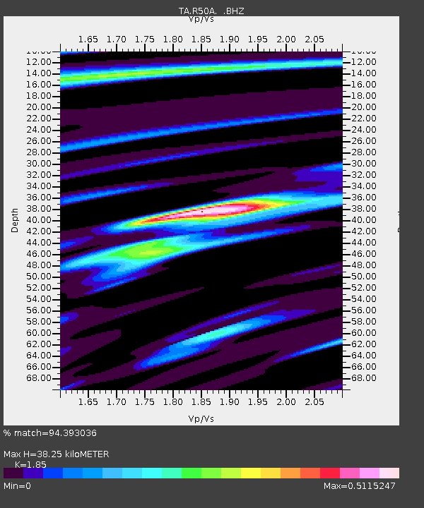
| Estimated Moho Depth: |
38.25 km |
| Estimated Crust Vp/Vs: |
1.85 |
| Assumed Crust Vp: |
6.498 km/s |
| Estimated Crust Vs: |
3.512 km/s |
| Estimated Crust Poisson's Ratio: |
0.29 |
|
| Radial Match: |
94.393036 % |
| Radial Bump: |
277 |
| Transverse Match: |
62.80162 % |
| Transverse Bump: |
400 |
| SOD ConfigId: |
494114 |
| Insert Time: |
2013-05-15 05:28:31.423 +0000 |
| GWidth: |
2.5 |
| Max Bumps: |
400 |
| Tol: |
0.001 |
|

Signal To Noise
| Channel | StoN | STA | LTA |
| TA:R50A: :BHZ:20130228T14:17:02.375Z | 8.424787 | 3.1842678E-6 | 3.7796423E-7 |
| TA:R50A: :BHN:20130228T14:17:02.375Z | 4.467833 | 9.858385E-7 | 2.206525E-7 |
| TA:R50A: :BHE:20130228T14:17:02.375Z | 1.9971493 | 6.022761E-7 | 3.0156787E-7 |
| Arrivals |
| Ps | 5.2 SECOND |
| PpPs | 16 SECOND |
| PsPs/PpSs | 21 SECOND |


