You are here: Home > Network List > TA - USArray Transportable Network (new EarthScope stations) Stations List
> Station N51A Ashland, OH, USA > Earthquake Result Viewer
N51A Ashland, OH, USA - Earthquake Result Viewer
| Earthquake location: |
Kuril Islands |
| Earthquake latitude/longitude: |
51.0/157.3 |
| Earthquake time(UTC): |
2013/02/28 (059) 14:05:50 GMT |
| Earthquake Depth: |
41 km |
| Earthquake Magnitude: |
6.4 MB, 6.7 MS, 6.9 MW, 6.8 MW |
| Earthquake Catalog/Contributor: |
WHDF/NEIC |
|
| Network: |
TA USArray Transportable Network (new EarthScope stations) |
| Station: |
N51A Ashland, OH, USA |
| Lat/Lon: |
40.92 N/82.37 W |
| Elevation: |
343 m |
|
| Distance: |
74.7 deg |
| Az: |
42.682 deg |
| Baz: |
325.541 deg |
| Ray Param: |
0.052063216 |
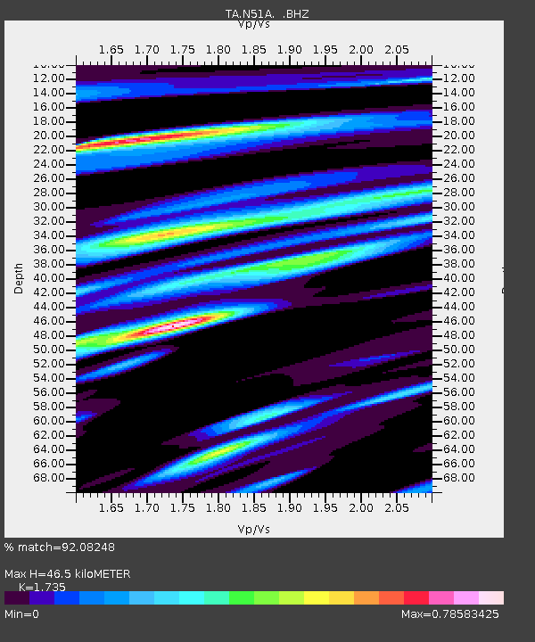
| Estimated Moho Depth: |
46.5 km |
| Estimated Crust Vp/Vs: |
1.74 |
| Assumed Crust Vp: |
6.498 km/s |
| Estimated Crust Vs: |
3.745 km/s |
| Estimated Crust Poisson's Ratio: |
0.25 |
|
| Radial Match: |
92.08248 % |
| Radial Bump: |
347 |
| Transverse Match: |
82.0546 % |
| Transverse Bump: |
400 |
| SOD ConfigId: |
494114 |
| Insert Time: |
2013-05-15 05:30:48.721 +0000 |
| GWidth: |
2.5 |
| Max Bumps: |
400 |
| Tol: |
0.001 |
|

Signal To Noise
| Channel | StoN | STA | LTA |
| TA:N51A: :BHZ:20130228T14:16:54.900024Z | 9.609027 | 3.6647893E-6 | 3.8139027E-7 |
| TA:N51A: :BHN:20130228T14:16:54.900024Z | 4.7048388 | 1.2750357E-6 | 2.7100518E-7 |
| TA:N51A: :BHE:20130228T14:16:54.900024Z | 2.4079473 | 7.156809E-7 | 2.972162E-7 |
| Arrivals |
| Ps | 5.4 SECOND |
| PpPs | 19 SECOND |
| PsPs/PpSs | 24 SECOND |


