You are here: Home > Network List > TA - USArray Transportable Network (new EarthScope stations) Stations List
> Station M47A Cromwell, IN, USA > Earthquake Result Viewer
M47A Cromwell, IN, USA - Earthquake Result Viewer

| Earthquake location: |
Kuril Islands |
| Earthquake latitude/longitude: |
51.0/157.3 |
| Earthquake time(UTC): |
2013/02/28 (059) 14:05:50 GMT |
| Earthquake Depth: |
41 km |
| Earthquake Magnitude: |
6.4 MB, 6.7 MS, 6.9 MW, 6.8 MW |
| Earthquake Catalog/Contributor: |
WHDF/NEIC |
|
| Network: |
TA USArray Transportable Network (new EarthScope stations) |
| Station: |
M47A Cromwell, IN, USA |
| Lat/Lon: |
41.36 N/85.62 W |
| Elevation: |
283 m |
|
| Distance: |
73.0 deg |
| Az: |
44.501 deg |
| Baz: |
323.919 deg |
| Ray Param: |
0.05324781 |
| Estimated Moho Depth: |
42.5 km |
| Estimated Crust Vp/Vs: |
1.81 |
| Assumed Crust Vp: |
6.498 km/s |
| Estimated Crust Vs: |
3.6 km/s |
| Estimated Crust Poisson's Ratio: |
0.28 |
|
| Radial Match: |
91.6802 % |
| Radial Bump: |
400 |
| Transverse Match: |
74.197296 % |
| Transverse Bump: |
400 |
| SOD ConfigId: |
494114 |
| Insert Time: |
2013-05-15 05:31:12.053 +0000 |
| GWidth: |
2.5 |
| Max Bumps: |
400 |
| Tol: |
0.001 |
|
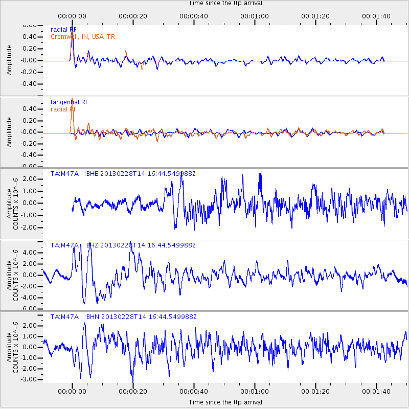
Signal To Noise
| Channel | StoN | STA | LTA |
| TA:M47A: :BHZ:20130228T14:16:44.549988Z | 6.874489 | 3.1192683E-6 | 4.5374549E-7 |
| TA:M47A: :BHN:20130228T14:16:44.549988Z | 4.090955 | 1.2884815E-6 | 3.1495864E-7 |
| TA:M47A: :BHE:20130228T14:16:44.549988Z | 3.3907018 | 1.09103E-6 | 3.2177113E-7 |
| Arrivals |
| Ps | 5.5 SECOND |
| PpPs | 18 SECOND |
| PsPs/PpSs | 23 SECOND |


