You are here: Home > Network List > TA - USArray Transportable Network (new EarthScope stations) Stations List
> Station K47A Vremontville, MI, USA > Earthquake Result Viewer
K47A Vremontville, MI, USA - Earthquake Result Viewer
| Earthquake location: |
Kuril Islands |
| Earthquake latitude/longitude: |
51.0/157.3 |
| Earthquake time(UTC): |
2013/02/28 (059) 14:05:50 GMT |
| Earthquake Depth: |
41 km |
| Earthquake Magnitude: |
6.4 MB, 6.7 MS, 6.9 MW, 6.8 MW |
| Earthquake Catalog/Contributor: |
WHDF/NEIC |
|
| Network: |
TA USArray Transportable Network (new EarthScope stations) |
| Station: |
K47A Vremontville, MI, USA |
| Lat/Lon: |
42.67 N/85.00 W |
| Elevation: |
275 m |
|
| Distance: |
72.2 deg |
| Az: |
43.3 deg |
| Baz: |
323.974 deg |
| Ray Param: |
0.05376422 |
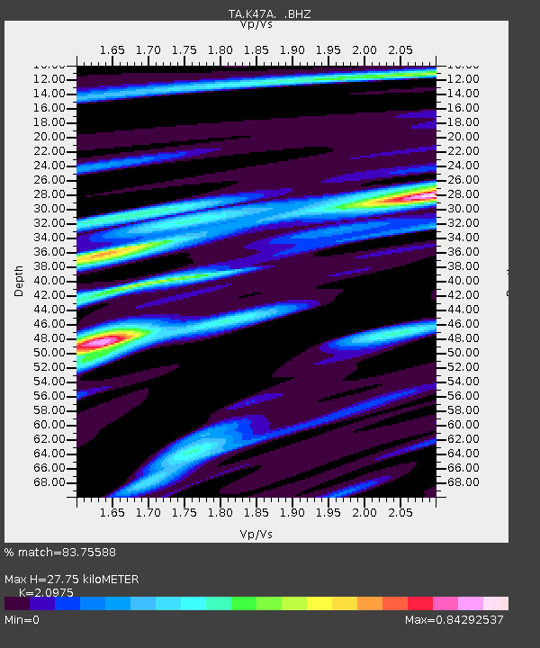
| Estimated Moho Depth: |
27.75 km |
| Estimated Crust Vp/Vs: |
2.10 |
| Assumed Crust Vp: |
6.483 km/s |
| Estimated Crust Vs: |
3.091 km/s |
| Estimated Crust Poisson's Ratio: |
0.35 |
|
| Radial Match: |
83.75588 % |
| Radial Bump: |
359 |
| Transverse Match: |
77.22326 % |
| Transverse Bump: |
400 |
| SOD ConfigId: |
494114 |
| Insert Time: |
2013-05-15 05:31:29.681 +0000 |
| GWidth: |
2.5 |
| Max Bumps: |
400 |
| Tol: |
0.001 |
|

Signal To Noise
| Channel | StoN | STA | LTA |
| TA:K47A: :BHZ:20130228T14:16:39.900024Z | 10.850449 | 3.6966069E-6 | 3.40687E-7 |
| TA:K47A: :BHN:20130228T14:16:39.900024Z | 3.8312836 | 1.358755E-6 | 3.5464743E-7 |
| TA:K47A: :BHE:20130228T14:16:39.900024Z | 3.9203277 | 1.1174354E-6 | 2.8503624E-7 |
| Arrivals |
| Ps | 4.8 SECOND |
| PpPs | 13 SECOND |
| PsPs/PpSs | 18 SECOND |


