You are here: Home > Network List > TA - USArray Transportable Network (new EarthScope stations) Stations List
> Station E53A Dumoine, Pontiac MRC, QC, CAN > Earthquake Result Viewer
E53A Dumoine, Pontiac MRC, QC, CAN - Earthquake Result Viewer
| Earthquake location: |
Kuril Islands |
| Earthquake latitude/longitude: |
51.0/157.3 |
| Earthquake time(UTC): |
2013/02/28 (059) 14:05:50 GMT |
| Earthquake Depth: |
41 km |
| Earthquake Magnitude: |
6.4 MB, 6.7 MS, 6.9 MW, 6.8 MW |
| Earthquake Catalog/Contributor: |
WHDF/NEIC |
|
| Network: |
TA USArray Transportable Network (new EarthScope stations) |
| Station: |
E53A Dumoine, Pontiac MRC, QC, CAN |
| Lat/Lon: |
46.38 N/77.66 W |
| Elevation: |
355 m |
|
| Distance: |
72.1 deg |
| Az: |
36.555 deg |
| Baz: |
327.035 deg |
| Ray Param: |
0.05381721 |
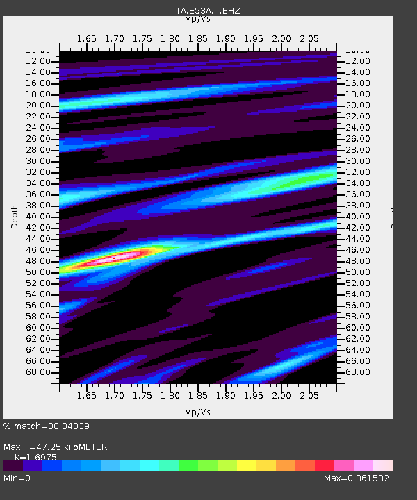
| Estimated Moho Depth: |
47.25 km |
| Estimated Crust Vp/Vs: |
1.70 |
| Assumed Crust Vp: |
6.622 km/s |
| Estimated Crust Vs: |
3.901 km/s |
| Estimated Crust Poisson's Ratio: |
0.23 |
|
| Radial Match: |
88.04039 % |
| Radial Bump: |
279 |
| Transverse Match: |
59.023205 % |
| Transverse Bump: |
400 |
| SOD ConfigId: |
494114 |
| Insert Time: |
2013-05-15 05:31:39.808 +0000 |
| GWidth: |
2.5 |
| Max Bumps: |
400 |
| Tol: |
0.001 |
|

Signal To Noise
| Channel | StoN | STA | LTA |
| TA:E53A: :BHZ:20130228T14:16:39.424988Z | 4.895728 | 2.8809734E-6 | 5.884668E-7 |
| TA:E53A: :BHN:20130228T14:16:39.424988Z | 2.7004707 | 9.1894174E-7 | 3.4028946E-7 |
| TA:E53A: :BHE:20130228T14:16:39.424988Z | 1.5540045 | 7.832054E-7 | 5.039917E-7 |
| Arrivals |
| Ps | 5.2 SECOND |
| PpPs | 19 SECOND |
| PsPs/PpSs | 24 SECOND |


