You are here: Home > Network List > TA - USArray Transportable Network (new EarthScope stations) Stations List
> Station J45A Montague, MI, USA > Earthquake Result Viewer
J45A Montague, MI, USA - Earthquake Result Viewer
| Earthquake location: |
Kuril Islands |
| Earthquake latitude/longitude: |
51.0/157.3 |
| Earthquake time(UTC): |
2013/02/28 (059) 14:05:50 GMT |
| Earthquake Depth: |
41 km |
| Earthquake Magnitude: |
6.4 MB, 6.7 MS, 6.9 MW, 6.8 MW |
| Earthquake Catalog/Contributor: |
WHDF/NEIC |
|
| Network: |
TA USArray Transportable Network (new EarthScope stations) |
| Station: |
J45A Montague, MI, USA |
| Lat/Lon: |
43.44 N/86.39 W |
| Elevation: |
209 m |
|
| Distance: |
71.0 deg |
| Az: |
43.685 deg |
| Baz: |
323.151 deg |
| Ray Param: |
0.05456815 |
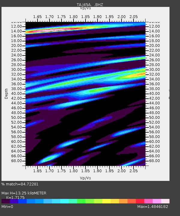
| Estimated Moho Depth: |
13.25 km |
| Estimated Crust Vp/Vs: |
1.72 |
| Assumed Crust Vp: |
6.483 km/s |
| Estimated Crust Vs: |
3.774 km/s |
| Estimated Crust Poisson's Ratio: |
0.24 |
|
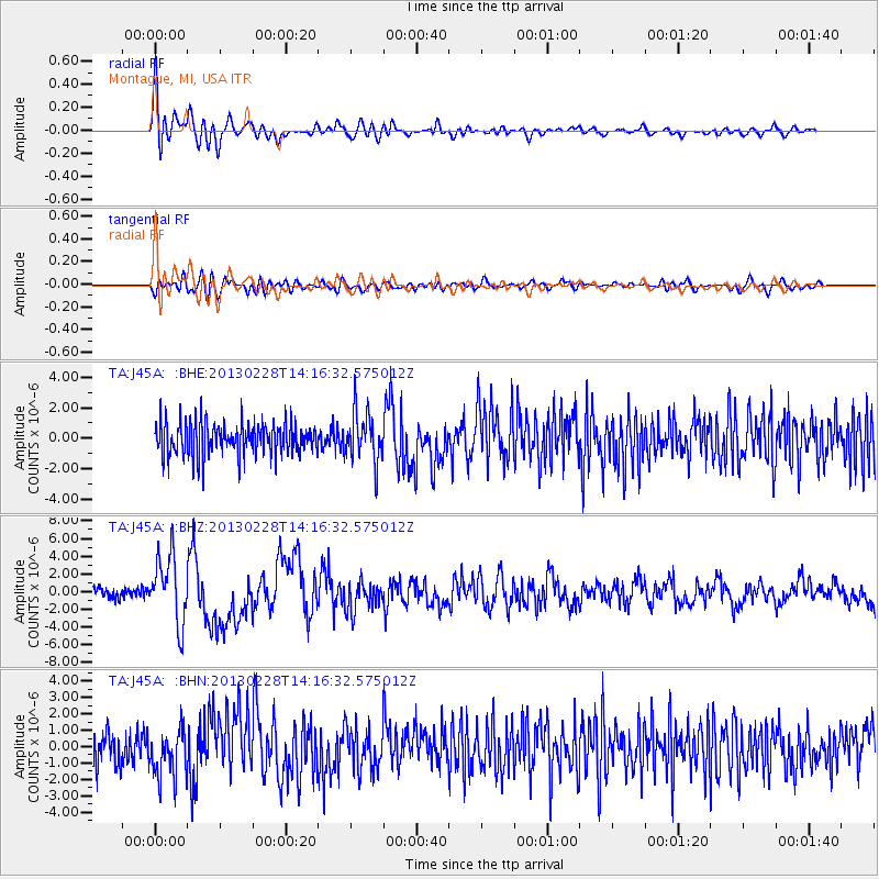
| Radial Match: |
84.72281 % |
| Radial Bump: |
400 |
| Transverse Match: |
68.419365 % |
| Transverse Bump: |
400 |
| SOD ConfigId: |
494114 |
| Insert Time: |
2013-05-15 05:31:47.738 +0000 |
| GWidth: |
2.5 |
| Max Bumps: |
400 |
| Tol: |
0.001 |
|
Signal To Noise
| Channel | StoN | STA | LTA |
| TA:J45A: :BHZ:20130228T14:16:32.575012Z | 5.650456 | 3.790756E-6 | 6.7087615E-7 |
| TA:J45A: :BHN:20130228T14:16:32.575012Z | 1.7164892 | 1.4733604E-6 | 8.5835694E-7 |
| TA:J45A: :BHE:20130228T14:16:32.575012Z | 1.5012124 | 1.6212234E-6 | 1.0799428E-6 |
| Arrivals |
| Ps | 1.5 SECOND |
| PpPs | 5.3 SECOND |
| PsPs/PpSs | 6.9 SECOND |


