You are here: Home > Network List > TA - USArray Transportable Network (new EarthScope stations) Stations List
> Station E51A G1948 Merrick Township, ON, CAN > Earthquake Result Viewer
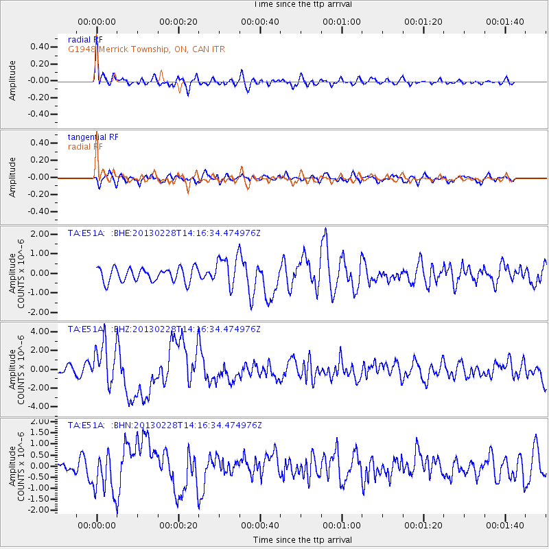
E51A G1948 Merrick Township, ON, CAN - Earthquake Result Viewer
*The percent match for this event was below the threshold and hence no stack was calculated.
| Earthquake location: |
Kuril Islands |
| Earthquake latitude/longitude: |
51.0/157.3 |
| Earthquake time(UTC): |
2013/02/28 (059) 14:05:50 GMT |
| Earthquake Depth: |
41 km |
| Earthquake Magnitude: |
6.4 MB, 6.7 MS, 6.9 MW, 6.8 MW |
| Earthquake Catalog/Contributor: |
WHDF/NEIC |
|
| Network: |
TA USArray Transportable Network (new EarthScope stations) |
| Station: |
E51A G1948 Merrick Township, ON, CAN |
| Lat/Lon: |
46.53 N/79.49 W |
| Elevation: |
369 m |
|
| Distance: |
71.3 deg |
| Az: |
37.575 deg |
| Baz: |
326.035 deg |
| Ray Param: |
$rayparam |
*The percent match for this event was below the threshold and hence was not used in the summary stack. |
|
| Radial Match: |
78.75455 % |
| Radial Bump: |
400 |
| Transverse Match: |
65.24757 % |
| Transverse Bump: |
400 |
| SOD ConfigId: |
494114 |
| Insert Time: |
2013-05-15 05:33:12.412 +0000 |
| GWidth: |
2.5 |
| Max Bumps: |
400 |
| Tol: |
0.001 |
|
Signal To Noise
| Channel | StoN | STA | LTA |
| TA:E51A: :BHZ:20130228T14:16:34.474976Z | 5.358327 | 2.2925162E-6 | 4.278418E-7 |
| TA:E51A: :BHN:20130228T14:16:34.474976Z | 2.7853699 | 9.560791E-7 | 3.4325035E-7 |
| TA:E51A: :BHE:20130228T14:16:34.474976Z | 2.2783291 | 8.030571E-7 | 3.5247632E-7 |
| Arrivals |
| Ps | |
| PpPs | |
| PsPs/PpSs | |


