You are here: Home > Network List > TA - USArray Transportable Network (new EarthScope stations) Stations List
> Station F51A Arnstein, ON, CAN > Earthquake Result Viewer
F51A Arnstein, ON, CAN - Earthquake Result Viewer
| Earthquake location: |
Kuril Islands |
| Earthquake latitude/longitude: |
51.0/157.3 |
| Earthquake time(UTC): |
2013/02/28 (059) 14:05:50 GMT |
| Earthquake Depth: |
41 km |
| Earthquake Magnitude: |
6.4 MB, 6.7 MS, 6.9 MW, 6.8 MW |
| Earthquake Catalog/Contributor: |
WHDF/NEIC |
|
| Network: |
TA USArray Transportable Network (new EarthScope stations) |
| Station: |
F51A Arnstein, ON, CAN |
| Lat/Lon: |
45.93 N/79.92 W |
| Elevation: |
239 m |
|
| Distance: |
71.6 deg |
| Az: |
38.189 deg |
| Baz: |
325.926 deg |
| Ray Param: |
0.054143567 |
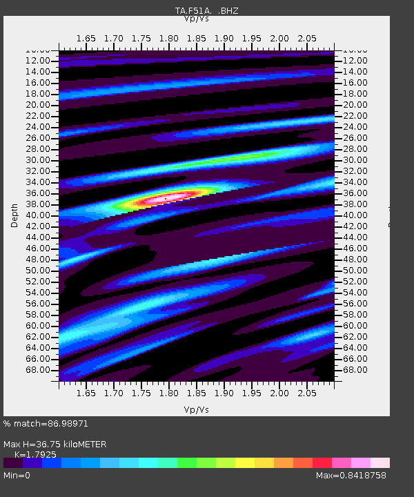
| Estimated Moho Depth: |
36.75 km |
| Estimated Crust Vp/Vs: |
1.79 |
| Assumed Crust Vp: |
6.577 km/s |
| Estimated Crust Vs: |
3.669 km/s |
| Estimated Crust Poisson's Ratio: |
0.27 |
|
| Radial Match: |
86.98971 % |
| Radial Bump: |
400 |
| Transverse Match: |
46.36003 % |
| Transverse Bump: |
400 |
| SOD ConfigId: |
494114 |
| Insert Time: |
2013-05-15 05:33:56.316 +0000 |
| GWidth: |
2.5 |
| Max Bumps: |
400 |
| Tol: |
0.001 |
|
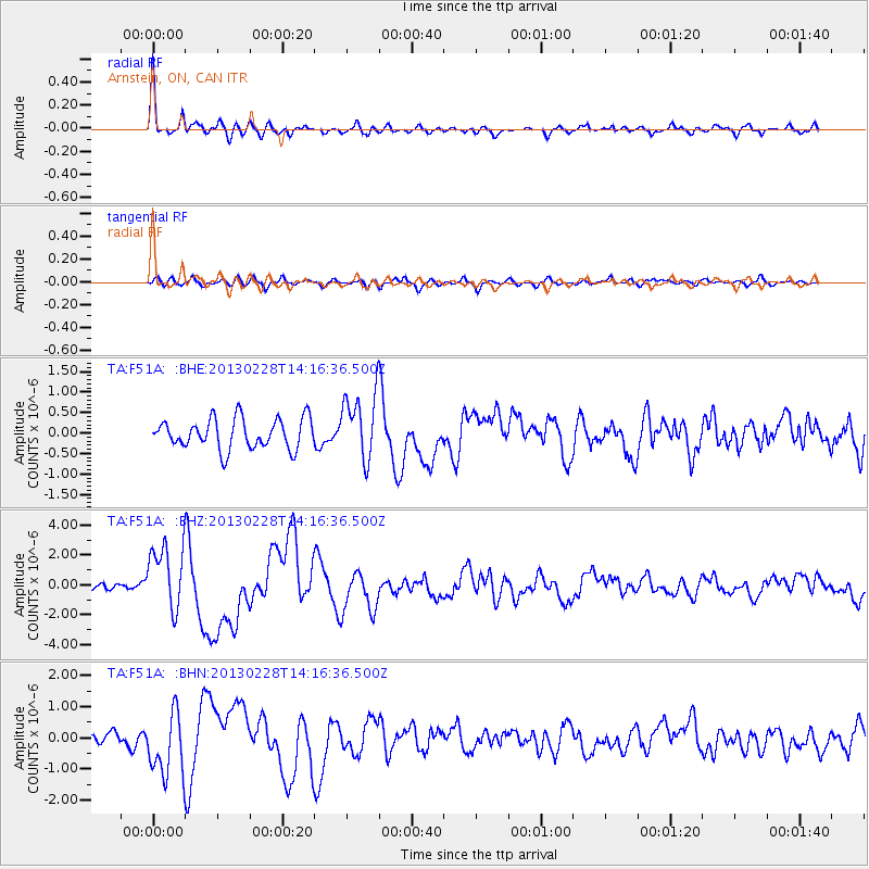
Signal To Noise
| Channel | StoN | STA | LTA |
| TA:F51A: :BHZ:20130228T14:16:36.500Z | 6.2342143 | 2.1845262E-6 | 3.5040924E-7 |
| TA:F51A: :BHN:20130228T14:16:36.500Z | 5.593574 | 1.0070945E-6 | 1.8004489E-7 |
| TA:F51A: :BHE:20130228T14:16:36.500Z | 2.2387433 | 8.154884E-7 | 3.642617E-7 |
| Arrivals |
| Ps | 4.6 SECOND |
| PpPs | 15 SECOND |
| PsPs/PpSs | 20 SECOND |


