You are here: Home > Network List > TA - USArray Transportable Network (new EarthScope stations) Stations List
> Station I46A Reed City, MI, USA > Earthquake Result Viewer
I46A Reed City, MI, USA - Earthquake Result Viewer
| Earthquake location: |
Kuril Islands |
| Earthquake latitude/longitude: |
51.0/157.3 |
| Earthquake time(UTC): |
2013/02/28 (059) 14:05:50 GMT |
| Earthquake Depth: |
41 km |
| Earthquake Magnitude: |
6.4 MB, 6.7 MS, 6.9 MW, 6.8 MW |
| Earthquake Catalog/Contributor: |
WHDF/NEIC |
|
| Network: |
TA USArray Transportable Network (new EarthScope stations) |
| Station: |
I46A Reed City, MI, USA |
| Lat/Lon: |
43.94 N/85.45 W |
| Elevation: |
359 m |
|
| Distance: |
71.0 deg |
| Az: |
42.786 deg |
| Baz: |
323.506 deg |
| Ray Param: |
0.05456648 |
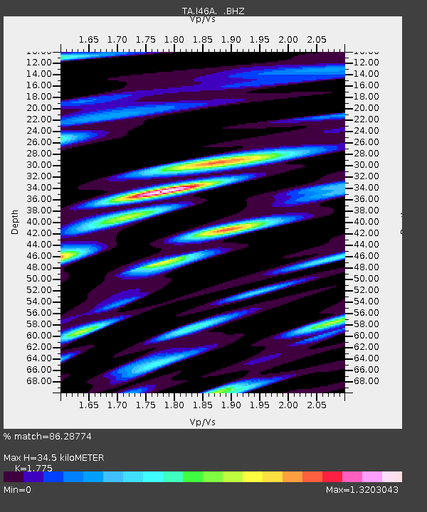
| Estimated Moho Depth: |
34.5 km |
| Estimated Crust Vp/Vs: |
1.77 |
| Assumed Crust Vp: |
6.483 km/s |
| Estimated Crust Vs: |
3.652 km/s |
| Estimated Crust Poisson's Ratio: |
0.27 |
|
| Radial Match: |
86.28774 % |
| Radial Bump: |
400 |
| Transverse Match: |
76.134254 % |
| Transverse Bump: |
400 |
| SOD ConfigId: |
494114 |
| Insert Time: |
2013-05-15 05:34:11.142 +0000 |
| GWidth: |
2.5 |
| Max Bumps: |
400 |
| Tol: |
0.001 |
|
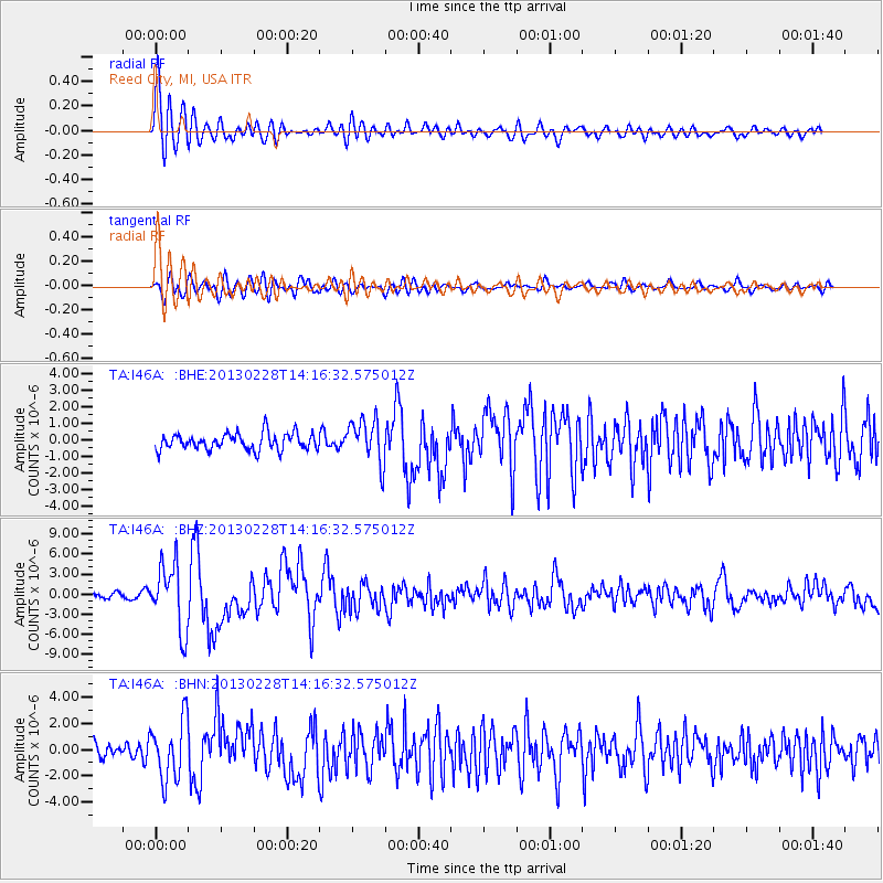
Signal To Noise
| Channel | StoN | STA | LTA |
| TA:I46A: :BHZ:20130228T14:16:32.575012Z | 16.573708 | 4.8664247E-6 | 2.9362317E-7 |
| TA:I46A: :BHN:20130228T14:16:32.575012Z | 3.8012674 | 2.2906088E-6 | 6.0259083E-7 |
| TA:I46A: :BHE:20130228T14:16:32.575012Z | 2.6167865 | 1.3130052E-6 | 5.017625E-7 |
| Arrivals |
| Ps | 4.3 SECOND |
| PpPs | 14 SECOND |
| PsPs/PpSs | 19 SECOND |


