You are here: Home > Network List > TA - USArray Transportable Network (new EarthScope stations) Stations List
> Station F49A Sandfield, ON, CAN > Earthquake Result Viewer
F49A Sandfield, ON, CAN - Earthquake Result Viewer
| Earthquake location: |
Kuril Islands |
| Earthquake latitude/longitude: |
51.0/157.3 |
| Earthquake time(UTC): |
2013/02/28 (059) 14:05:50 GMT |
| Earthquake Depth: |
41 km |
| Earthquake Magnitude: |
6.4 MB, 6.7 MS, 6.9 MW, 6.8 MW |
| Earthquake Catalog/Contributor: |
WHDF/NEIC |
|
| Network: |
TA USArray Transportable Network (new EarthScope stations) |
| Station: |
F49A Sandfield, ON, CAN |
| Lat/Lon: |
45.76 N/82.04 W |
| Elevation: |
230 m |
|
| Distance: |
70.9 deg |
| Az: |
39.581 deg |
| Baz: |
324.852 deg |
| Ray Param: |
0.054605566 |
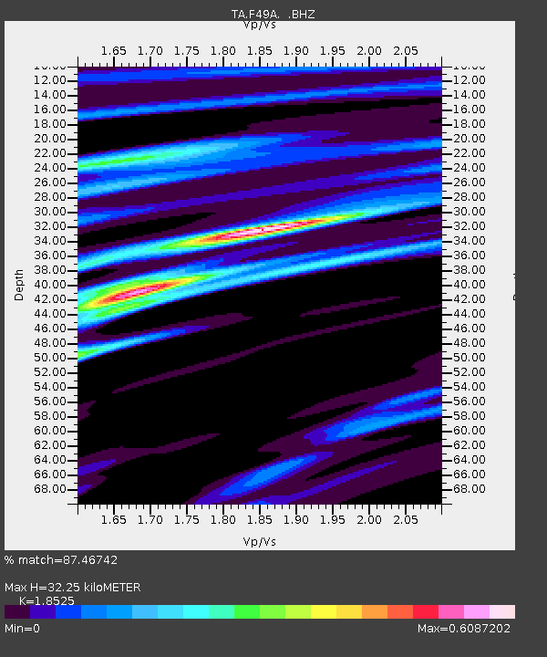
| Estimated Moho Depth: |
32.25 km |
| Estimated Crust Vp/Vs: |
1.85 |
| Assumed Crust Vp: |
6.483 km/s |
| Estimated Crust Vs: |
3.499 km/s |
| Estimated Crust Poisson's Ratio: |
0.29 |
|
| Radial Match: |
87.46742 % |
| Radial Bump: |
378 |
| Transverse Match: |
66.52558 % |
| Transverse Bump: |
400 |
| SOD ConfigId: |
494114 |
| Insert Time: |
2013-05-15 05:35:08.303 +0000 |
| GWidth: |
2.5 |
| Max Bumps: |
400 |
| Tol: |
0.001 |
|
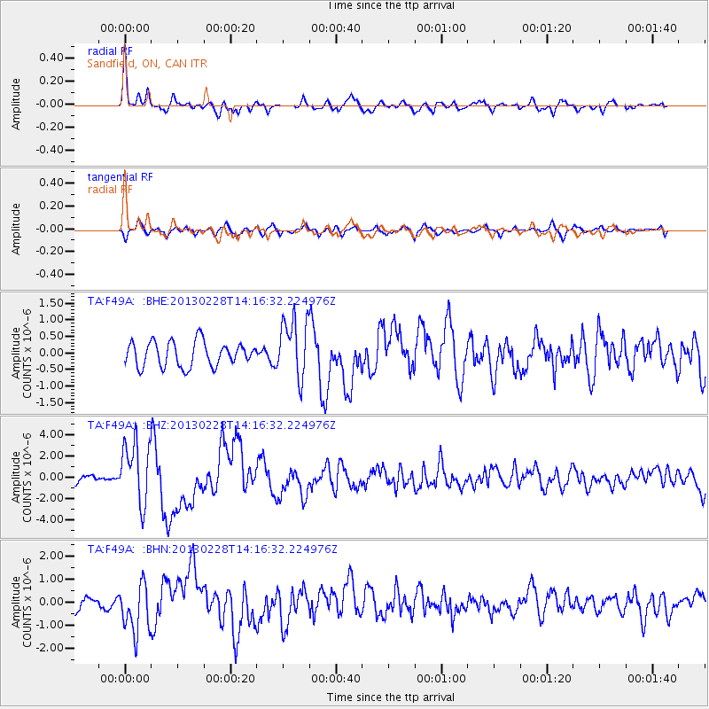
Signal To Noise
| Channel | StoN | STA | LTA |
| TA:F49A: :BHZ:20130228T14:16:32.224976Z | 6.5385594 | 2.966882E-6 | 4.5375162E-7 |
| TA:F49A: :BHN:20130228T14:16:32.224976Z | 3.0556326 | 1.0628636E-6 | 3.478375E-7 |
| TA:F49A: :BHE:20130228T14:16:32.224976Z | 2.4465468 | 9.0976795E-7 | 3.71858E-7 |
| Arrivals |
| Ps | 4.4 SECOND |
| PpPs | 14 SECOND |
| PsPs/PpSs | 18 SECOND |


