You are here: Home > Network List > TA - USArray Transportable Network (new EarthScope stations) Stations List
> Station K51A Iona Station, ON, CAN > Earthquake Result Viewer
K51A Iona Station, ON, CAN - Earthquake Result Viewer

| Earthquake location: |
Kuril Islands |
| Earthquake latitude/longitude: |
51.0/157.3 |
| Earthquake time(UTC): |
2013/02/28 (059) 14:05:50 GMT |
| Earthquake Depth: |
41 km |
| Earthquake Magnitude: |
6.4 MB, 6.7 MS, 6.9 MW, 6.8 MW |
| Earthquake Catalog/Contributor: |
WHDF/NEIC |
|
| Network: |
TA USArray Transportable Network (new EarthScope stations) |
| Station: |
K51A Iona Station, ON, CAN |
| Lat/Lon: |
42.72 N/81.51 W |
| Elevation: |
217 m |
|
| Distance: |
73.6 deg |
| Az: |
41.068 deg |
| Baz: |
325.677 deg |
| Ray Param: |
0.052816186 |
| Estimated Moho Depth: |
35.0 km |
| Estimated Crust Vp/Vs: |
1.61 |
| Assumed Crust Vp: |
6.53 km/s |
| Estimated Crust Vs: |
4.069 km/s |
| Estimated Crust Poisson's Ratio: |
0.18 |
|
| Radial Match: |
89.23442 % |
| Radial Bump: |
400 |
| Transverse Match: |
67.7248 % |
| Transverse Bump: |
400 |
| SOD ConfigId: |
494114 |
| Insert Time: |
2013-05-15 05:35:59.837 +0000 |
| GWidth: |
2.5 |
| Max Bumps: |
400 |
| Tol: |
0.001 |
|
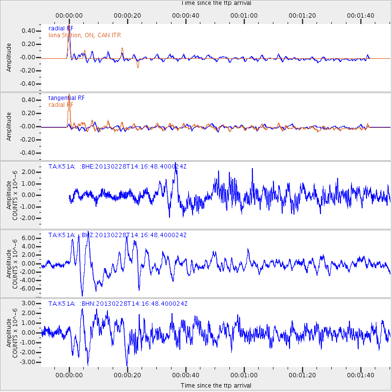
Signal To Noise
| Channel | StoN | STA | LTA |
| TA:K51A: :BHZ:20130228T14:16:48.400024Z | 10.1552925 | 3.7955356E-6 | 3.7374951E-7 |
| TA:K51A: :BHN:20130228T14:16:48.400024Z | 4.7913947 | 1.348495E-6 | 2.81441E-7 |
| TA:K51A: :BHE:20130228T14:16:48.400024Z | 2.5765939 | 7.4013786E-7 | 2.8725435E-7 |
| Arrivals |
| Ps | 3.4 SECOND |
| PpPs | 13 SECOND |
| PsPs/PpSs | 17 SECOND |


