You are here: Home > Network List > TA - USArray Transportable Network (new EarthScope stations) Stations List
> Station L50A Kingsville, ON, CAN > Earthquake Result Viewer
L50A Kingsville, ON, CAN - Earthquake Result Viewer

| Earthquake location: |
Kuril Islands |
| Earthquake latitude/longitude: |
51.0/157.3 |
| Earthquake time(UTC): |
2013/02/28 (059) 14:05:50 GMT |
| Earthquake Depth: |
41 km |
| Earthquake Magnitude: |
6.4 MB, 6.7 MS, 6.9 MW, 6.8 MW |
| Earthquake Catalog/Contributor: |
WHDF/NEIC |
|
| Network: |
TA USArray Transportable Network (new EarthScope stations) |
| Station: |
L50A Kingsville, ON, CAN |
| Lat/Lon: |
42.04 N/82.81 W |
| Elevation: |
187 m |
|
| Distance: |
73.6 deg |
| Az: |
42.297 deg |
| Baz: |
325.149 deg |
| Ray Param: |
0.052808426 |
| Estimated Moho Depth: |
32.0 km |
| Estimated Crust Vp/Vs: |
1.91 |
| Assumed Crust Vp: |
6.483 km/s |
| Estimated Crust Vs: |
3.39 km/s |
| Estimated Crust Poisson's Ratio: |
0.31 |
|
| Radial Match: |
92.199234 % |
| Radial Bump: |
400 |
| Transverse Match: |
78.59996 % |
| Transverse Bump: |
400 |
| SOD ConfigId: |
494114 |
| Insert Time: |
2013-05-15 05:36:08.320 +0000 |
| GWidth: |
2.5 |
| Max Bumps: |
400 |
| Tol: |
0.001 |
|
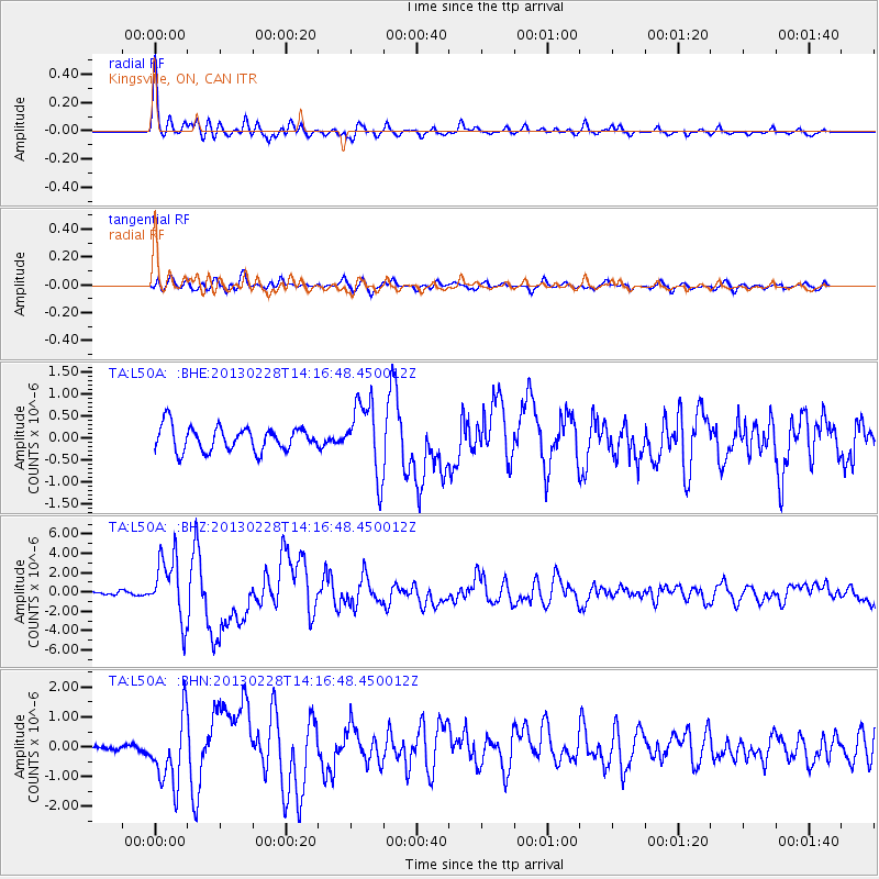
Signal To Noise
| Channel | StoN | STA | LTA |
| TA:L50A: :BHZ:20130228T14:16:48.450012Z | 11.409596 | 3.25559E-6 | 2.8533788E-7 |
| TA:L50A: :BHN:20130228T14:16:48.450012Z | 4.2851367 | 1.1318633E-6 | 2.6413704E-7 |
| TA:L50A: :BHE:20130228T14:16:48.450012Z | 2.9645536 | 8.147229E-7 | 2.7482145E-7 |
| Arrivals |
| Ps | 4.7 SECOND |
| PpPs | 14 SECOND |
| PsPs/PpSs | 19 SECOND |


