You are here: Home > Network List > TA - USArray Transportable Network (new EarthScope stations) Stations List
> Station L53A Girard, PA, USA > Earthquake Result Viewer
L53A Girard, PA, USA - Earthquake Result Viewer
| Earthquake location: |
Kuril Islands |
| Earthquake latitude/longitude: |
51.0/157.3 |
| Earthquake time(UTC): |
2013/02/28 (059) 14:05:50 GMT |
| Earthquake Depth: |
41 km |
| Earthquake Magnitude: |
6.4 MB, 6.7 MS, 6.9 MW, 6.8 MW |
| Earthquake Catalog/Contributor: |
WHDF/NEIC |
|
| Network: |
TA USArray Transportable Network (new EarthScope stations) |
| Station: |
L53A Girard, PA, USA |
| Lat/Lon: |
41.95 N/80.26 W |
| Elevation: |
355 m |
|
| Distance: |
74.8 deg |
| Az: |
40.716 deg |
| Baz: |
326.419 deg |
| Ray Param: |
0.052041583 |
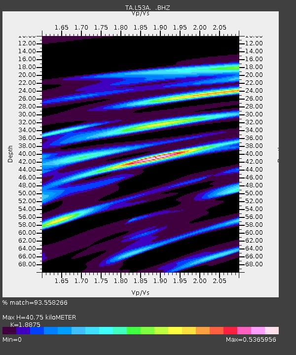
| Estimated Moho Depth: |
40.75 km |
| Estimated Crust Vp/Vs: |
1.89 |
| Assumed Crust Vp: |
6.483 km/s |
| Estimated Crust Vs: |
3.434 km/s |
| Estimated Crust Poisson's Ratio: |
0.30 |
|
| Radial Match: |
93.558266 % |
| Radial Bump: |
356 |
| Transverse Match: |
75.950005 % |
| Transverse Bump: |
400 |
| SOD ConfigId: |
494114 |
| Insert Time: |
2013-05-15 05:37:28.249 +0000 |
| GWidth: |
2.5 |
| Max Bumps: |
400 |
| Tol: |
0.001 |
|

Signal To Noise
| Channel | StoN | STA | LTA |
| TA:L53A: :BHZ:20130228T14:16:55.099976Z | 8.668538 | 4.051041E-6 | 4.6732686E-7 |
| TA:L53A: :BHN:20130228T14:16:55.099976Z | 7.1414995 | 1.7594159E-6 | 2.4636506E-7 |
| TA:L53A: :BHE:20130228T14:16:55.099976Z | 2.7565825 | 7.272074E-7 | 2.6380758E-7 |
| Arrivals |
| Ps | 5.8 SECOND |
| PpPs | 18 SECOND |
| PsPs/PpSs | 23 SECOND |


