You are here: Home > Network List > TA - USArray Transportable Network (new EarthScope stations) Stations List
> Station T54A Tazewell, VA, USA > Earthquake Result Viewer
T54A Tazewell, VA, USA - Earthquake Result Viewer
| Earthquake location: |
Kuril Islands |
| Earthquake latitude/longitude: |
51.0/157.3 |
| Earthquake time(UTC): |
2013/02/28 (059) 14:05:50 GMT |
| Earthquake Depth: |
41 km |
| Earthquake Magnitude: |
6.4 MB, 6.7 MS, 6.9 MW, 6.8 MW |
| Earthquake Catalog/Contributor: |
WHDF/NEIC |
|
| Network: |
TA USArray Transportable Network (new EarthScope stations) |
| Station: |
T54A Tazewell, VA, USA |
| Lat/Lon: |
37.06 N/81.58 W |
| Elevation: |
852 m |
|
| Distance: |
78.3 deg |
| Az: |
44.367 deg |
| Baz: |
326.435 deg |
| Ray Param: |
0.049683657 |
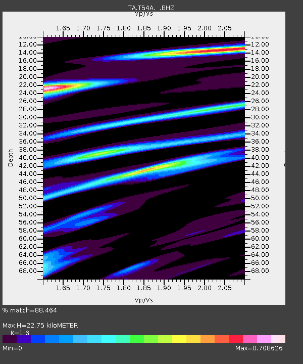
| Estimated Moho Depth: |
22.75 km |
| Estimated Crust Vp/Vs: |
1.60 |
| Assumed Crust Vp: |
6.159 km/s |
| Estimated Crust Vs: |
3.849 km/s |
| Estimated Crust Poisson's Ratio: |
0.18 |
|
| Radial Match: |
88.464 % |
| Radial Bump: |
364 |
| Transverse Match: |
66.92383 % |
| Transverse Bump: |
400 |
| SOD ConfigId: |
494114 |
| Insert Time: |
2013-05-15 05:38:14.308 +0000 |
| GWidth: |
2.5 |
| Max Bumps: |
400 |
| Tol: |
0.001 |
|
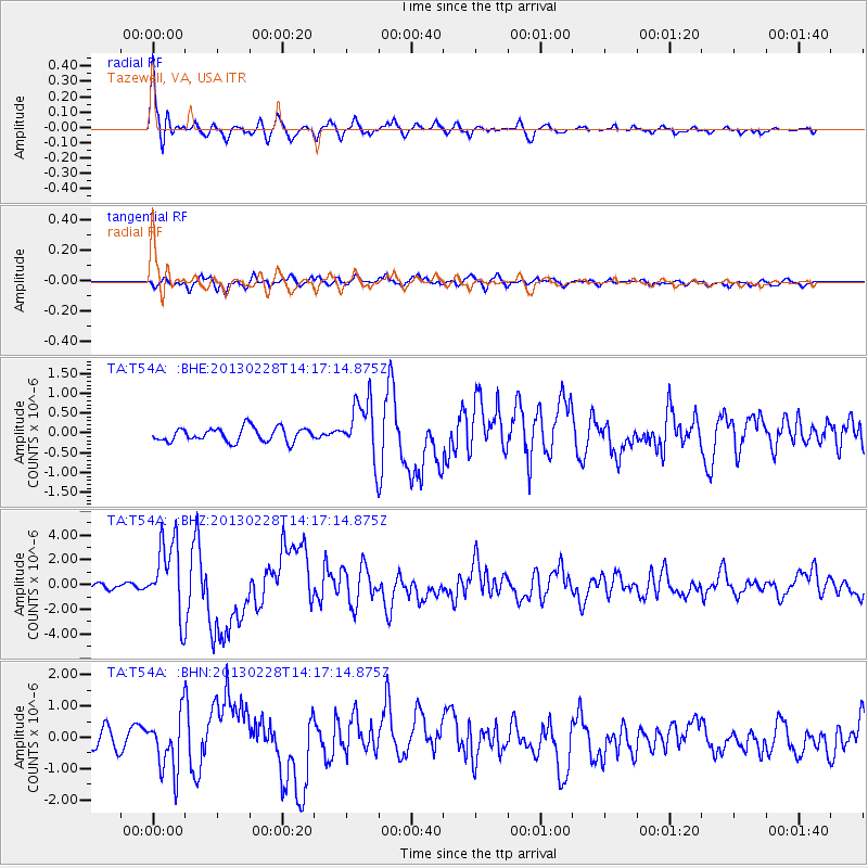
Signal To Noise
| Channel | StoN | STA | LTA |
| TA:T54A: :BHZ:20130228T14:17:14.875Z | 14.195613 | 3.0129106E-6 | 2.1224238E-7 |
| TA:T54A: :BHN:20130228T14:17:14.875Z | 2.3933141 | 8.704756E-7 | 3.637114E-7 |
| TA:T54A: :BHE:20130228T14:17:14.875Z | 4.152157 | 7.273281E-7 | 1.7516874E-7 |
| Arrivals |
| Ps | 2.3 SECOND |
| PpPs | 9.3 SECOND |
| PsPs/PpSs | 12 SECOND |


