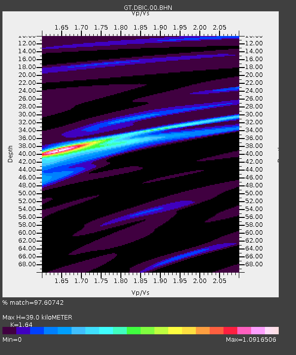
DBIC Dimbokro, Cote d'Ivoire - Earthquake Result Viewer
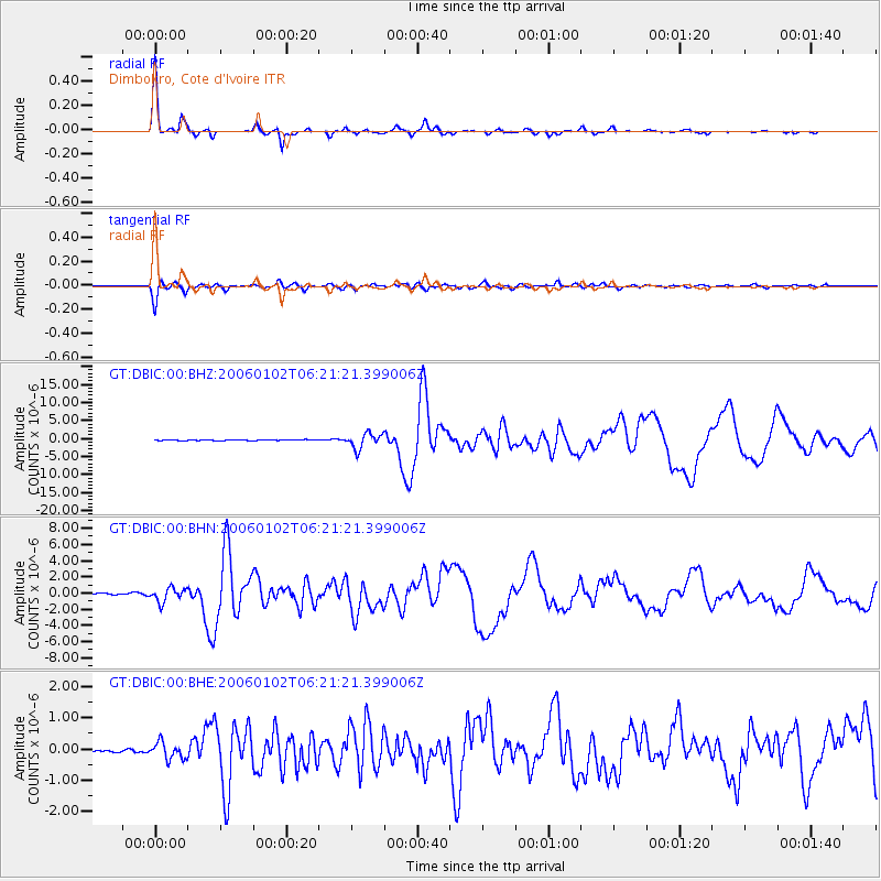
Earthquake location: Southwestern Atlantic Ocean
Earthquake latitude/longitude: -60.9/-21.6
Earthquake time(UTC): 2006/01/02 (002) 06:10:49 GMT
Earthquake Depth: 10 km
Earthquake Magnitude: 6.4 MB, 7.3 MS, 7.4 MW, 7.1 MW
Earthquake Catalog/Contributor: WHDF/NEIC
Network: GT Global Telemetered Seismograph Network (USAF/USGS)
Station: DBIC Dimbokro, Cote d'Ivoire
Lat/Lon: 6.67 N/4.86 W
Elevation: 125 m
Distance: 68.7 deg
Az: 17.865 deg
Baz: 188.674 deg
Ray Param: 0.056156658
Estimated Moho Depth: 39.0 km
Estimated Crust Vp/Vs: 1.64
Assumed Crust Vp: 6.419 km/s
Estimated Crust Vs: 3.914 km/s
Estimated Crust Poisson's Ratio: 0.20
Radial Match: 97.60742 %
Radial Bump: 215
Transverse Match: 92.64943 %
Transverse Bump: 400
SOD ConfigId: 4977
Insert Time: 2010-02-27 01:57:11.300 +0000
GWidth: 2.5
Max Bumps: 400
Tol: 0.001

Signal To Noise

ChannelStoNSTALTA
GT:DBIC:00:BHN:20060102T06:21:21.399006Z10.8781148.539305E-77.8499866E-8
GT:DBIC:00:BHE:20060102T06:21:21.399006Z3.23091912.6740494E-78.276436E-8
GT:DBIC:00:BHZ:20060102T06:21:21.399006Z18.108172.1214726E-61.17155544E-7
Arrivals
Ps4.1 SECOND
PpPs15 SECOND
PsPs/PpSs19 SECOND