You are here: Home > Network List > TA - USArray Transportable Network (new EarthScope stations) Stations List
> Station Y56A Pelion, SC, USA > Earthquake Result Viewer
Y56A Pelion, SC, USA - Earthquake Result Viewer
| Earthquake location: |
Kuril Islands |
| Earthquake latitude/longitude: |
51.0/157.3 |
| Earthquake time(UTC): |
2013/02/28 (059) 14:05:50 GMT |
| Earthquake Depth: |
41 km |
| Earthquake Magnitude: |
6.4 MB, 6.7 MS, 6.9 MW, 6.8 MW |
| Earthquake Catalog/Contributor: |
WHDF/NEIC |
|
| Network: |
TA USArray Transportable Network (new EarthScope stations) |
| Station: |
Y56A Pelion, SC, USA |
| Lat/Lon: |
33.79 N/81.30 W |
| Elevation: |
154 m |
|
| Distance: |
81.1 deg |
| Az: |
46.0 deg |
| Baz: |
326.884 deg |
| Ray Param: |
0.04774086 |
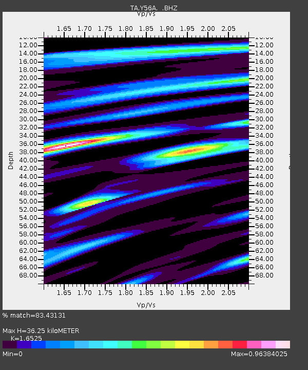
| Estimated Moho Depth: |
36.25 km |
| Estimated Crust Vp/Vs: |
1.65 |
| Assumed Crust Vp: |
6.565 km/s |
| Estimated Crust Vs: |
3.972 km/s |
| Estimated Crust Poisson's Ratio: |
0.21 |
|
| Radial Match: |
83.43131 % |
| Radial Bump: |
400 |
| Transverse Match: |
51.36083 % |
| Transverse Bump: |
318 |
| SOD ConfigId: |
494114 |
| Insert Time: |
2013-05-15 05:39:26.674 +0000 |
| GWidth: |
2.5 |
| Max Bumps: |
400 |
| Tol: |
0.001 |
|

Signal To Noise
| Channel | StoN | STA | LTA |
| TA:Y56A: :BHZ:20130228T14:17:30.250Z | 7.55296 | 2.4804804E-6 | 3.284117E-7 |
| TA:Y56A: :BHN:20130228T14:17:30.250Z | 1.3416529 | 1.021096E-6 | 7.610731E-7 |
| TA:Y56A: :BHE:20130228T14:17:30.250Z | 1.2171534 | 5.868267E-7 | 4.821304E-7 |
| Arrivals |
| Ps | 3.7 SECOND |
| PpPs | 14 SECOND |
| PsPs/PpSs | 18 SECOND |


