You are here: Home > Network List > UW - Pacific Northwest Regional Seismic Network Stations List
> Station MRBL Marblemount, WA, USA > Earthquake Result Viewer
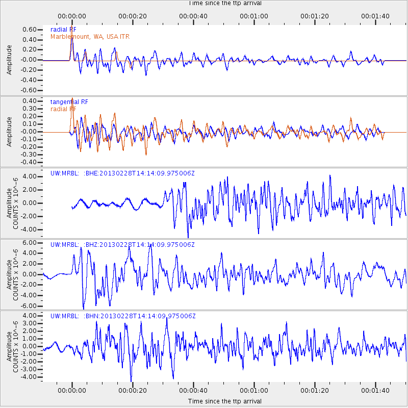
MRBL Marblemount, WA, USA - Earthquake Result Viewer
*The percent match for this event was below the threshold and hence no stack was calculated.
| Earthquake location: |
Kuril Islands |
| Earthquake latitude/longitude: |
51.0/157.3 |
| Earthquake time(UTC): |
2013/02/28 (059) 14:05:50 GMT |
| Earthquake Depth: |
41 km |
| Earthquake Magnitude: |
6.4 MB, 6.7 MS, 6.9 MW, 6.8 MW |
| Earthquake Catalog/Contributor: |
WHDF/NEIC |
|
| Network: |
UW Pacific Northwest Regional Seismic Network |
| Station: |
MRBL Marblemount, WA, USA |
| Lat/Lon: |
48.52 N/121.48 W |
| Elevation: |
75 m |
|
| Distance: |
50.0 deg |
| Az: |
59.057 deg |
| Baz: |
305.323 deg |
| Ray Param: |
$rayparam |
*The percent match for this event was below the threshold and hence was not used in the summary stack. |
|
| Radial Match: |
79.258804 % |
| Radial Bump: |
400 |
| Transverse Match: |
81.45177 % |
| Transverse Bump: |
400 |
| SOD ConfigId: |
494114 |
| Insert Time: |
2013-05-15 05:40:58.528 +0000 |
| GWidth: |
2.5 |
| Max Bumps: |
400 |
| Tol: |
0.001 |
|
Signal To Noise
| Channel | StoN | STA | LTA |
| UW:MRBL: :BHZ:20130228T14:14:09.975006Z | 8.412555 | 3.0451429E-6 | 3.6197596E-7 |
| UW:MRBL: :BHN:20130228T14:14:09.975006Z | 2.2009723 | 6.4206955E-7 | 2.9172088E-7 |
| UW:MRBL: :BHE:20130228T14:14:09.975006Z | 3.3536355 | 1.5103013E-6 | 4.5034747E-7 |
| Arrivals |
| Ps | |
| PpPs | |
| PsPs/PpSs | |


