You are here: Home > Network List > CI - Caltech Regional Seismic Network Stations List
> Station FUR Furnace Creek, CA, USA > Earthquake Result Viewer
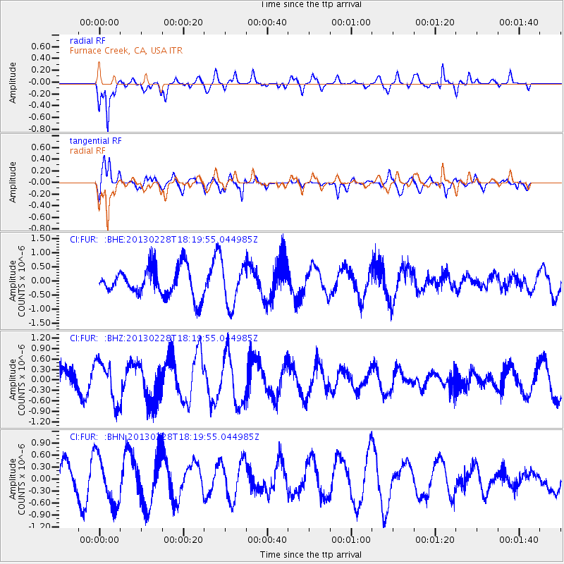
FUR Furnace Creek, CA, USA - Earthquake Result Viewer
*The percent match for this event was below the threshold and hence no stack was calculated.
| Earthquake location: |
Santa Cruz Islands |
| Earthquake latitude/longitude: |
-10.9/165.9 |
| Earthquake time(UTC): |
2013/02/28 (059) 18:07:48 GMT |
| Earthquake Depth: |
39 km |
| Earthquake Magnitude: |
5.5 MB, 5.4 MS, 5.8 MW, 5.8 MW |
| Earthquake Catalog/Contributor: |
WHDF/NEIC |
|
| Network: |
CI Caltech Regional Seismic Network |
| Station: |
FUR Furnace Creek, CA, USA |
| Lat/Lon: |
36.47 N/116.86 W |
| Elevation: |
-37.0 m |
|
| Distance: |
86.3 deg |
| Az: |
51.975 deg |
| Baz: |
253.708 deg |
| Ray Param: |
$rayparam |
*The percent match for this event was below the threshold and hence was not used in the summary stack. |
|
| Radial Match: |
80.75754 % |
| Radial Bump: |
400 |
| Transverse Match: |
50.89722 % |
| Transverse Bump: |
400 |
| SOD ConfigId: |
494114 |
| Insert Time: |
2013-05-15 05:46:17.818 +0000 |
| GWidth: |
2.5 |
| Max Bumps: |
400 |
| Tol: |
0.001 |
|
Signal To Noise
| Channel | StoN | STA | LTA |
| CI:FUR: :BHZ:20130228T18:19:55.044985Z | 2.1249352 | 5.934031E-7 | 2.7925705E-7 |
| CI:FUR: :BHN:20130228T18:19:55.044985Z | 1.7636253 | 5.965282E-7 | 3.3823974E-7 |
| CI:FUR: :BHE:20130228T18:19:55.044985Z | 1.4090596 | 7.127679E-7 | 5.058465E-7 |
| Arrivals |
| Ps | |
| PpPs | |
| PsPs/PpSs | |


