You are here: Home > Network List > CI - Caltech Regional Seismic Network Stations List
> Station MPM Manuel Prospect Mine, California, USA > Earthquake Result Viewer
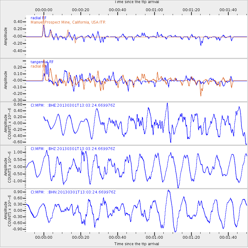
MPM Manuel Prospect Mine, California, USA - Earthquake Result Viewer
*The percent match for this event was below the threshold and hence no stack was calculated.
| Earthquake location: |
Kuril Islands |
| Earthquake latitude/longitude: |
50.9/157.5 |
| Earthquake time(UTC): |
2013/03/01 (060) 12:53:51 GMT |
| Earthquake Depth: |
33 km |
| Earthquake Magnitude: |
5.7 MB, 5.8 MS, 6.4 MW, 6.4 MW |
| Earthquake Catalog/Contributor: |
WHDF/NEIC |
|
| Network: |
CI Caltech Regional Seismic Network |
| Station: |
MPM Manuel Prospect Mine, California, USA |
| Lat/Lon: |
36.06 N/117.49 W |
| Elevation: |
185 m |
|
| Distance: |
60.1 deg |
| Az: |
68.555 deg |
| Baz: |
313.327 deg |
| Ray Param: |
$rayparam |
*The percent match for this event was below the threshold and hence was not used in the summary stack. |
|
| Radial Match: |
66.76695 % |
| Radial Bump: |
400 |
| Transverse Match: |
85.60073 % |
| Transverse Bump: |
400 |
| SOD ConfigId: |
494114 |
| Insert Time: |
2013-05-15 06:02:34.170 +0000 |
| GWidth: |
2.5 |
| Max Bumps: |
400 |
| Tol: |
0.001 |
|
Signal To Noise
| Channel | StoN | STA | LTA |
| CI:MPM: :BHZ:20130301T13:03:24.669976Z | 2.6632032 | 7.3435587E-7 | 2.757416E-7 |
| CI:MPM: :BHN:20130301T13:03:24.669976Z | 1.2700835 | 3.358569E-7 | 2.6443684E-7 |
| CI:MPM: :BHE:20130301T13:03:24.669976Z | 1.1795431 | 2.0775353E-7 | 1.7613051E-7 |
| Arrivals |
| Ps | |
| PpPs | |
| PsPs/PpSs | |


