You are here: Home > Network List > IW - Intermountain West Stations List
> Station DLMT Dillon, Montana, USA > Earthquake Result Viewer
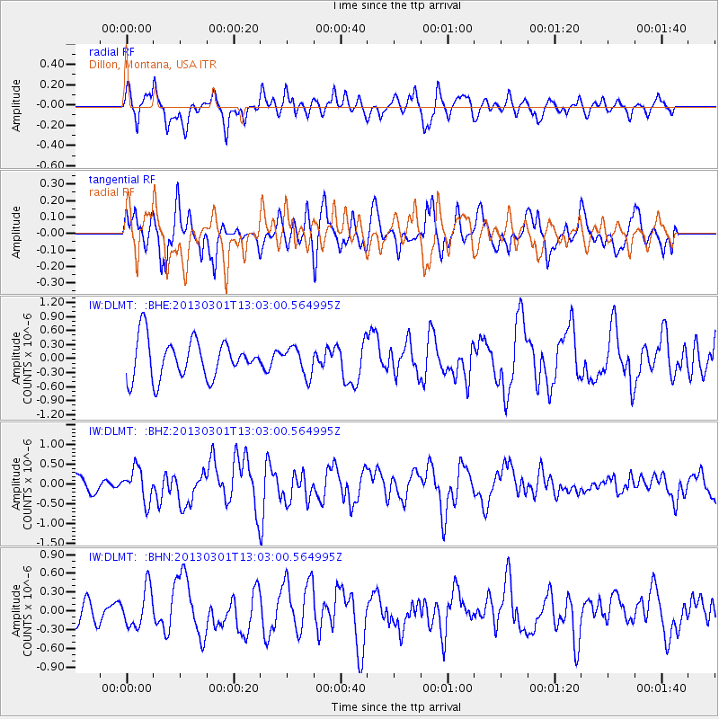
DLMT Dillon, Montana, USA - Earthquake Result Viewer
*The percent match for this event was below the threshold and hence no stack was calculated.
| Earthquake location: |
Kuril Islands |
| Earthquake latitude/longitude: |
50.9/157.5 |
| Earthquake time(UTC): |
2013/03/01 (060) 12:53:51 GMT |
| Earthquake Depth: |
33 km |
| Earthquake Magnitude: |
5.7 MB, 5.8 MS, 6.4 MW, 6.4 MW |
| Earthquake Catalog/Contributor: |
WHDF/NEIC |
|
| Network: |
IW Intermountain West |
| Station: |
DLMT Dillon, Montana, USA |
| Lat/Lon: |
45.36 N/112.60 W |
| Elevation: |
1569 m |
|
| Distance: |
56.7 deg |
| Az: |
57.527 deg |
| Baz: |
310.726 deg |
| Ray Param: |
$rayparam |
*The percent match for this event was below the threshold and hence was not used in the summary stack. |
|
| Radial Match: |
54.553886 % |
| Radial Bump: |
400 |
| Transverse Match: |
64.33743 % |
| Transverse Bump: |
400 |
| SOD ConfigId: |
494114 |
| Insert Time: |
2013-05-15 06:06:27.947 +0000 |
| GWidth: |
2.5 |
| Max Bumps: |
400 |
| Tol: |
0.001 |
|
Signal To Noise
| Channel | StoN | STA | LTA |
| IW:DLMT: :BHZ:20130301T13:03:00.564995Z | 2.2899814 | 4.1450033E-7 | 1.8100599E-7 |
| IW:DLMT: :BHN:20130301T13:03:00.564995Z | 1.183738 | 3.1424625E-7 | 2.6546942E-7 |
| IW:DLMT: :BHE:20130301T13:03:00.564995Z | 0.7266439 | 2.996639E-7 | 4.123944E-7 |
| Arrivals |
| Ps | |
| PpPs | |
| PsPs/PpSs | |


