You are here: Home > Network List > TA - USArray Transportable Network (new EarthScope stations) Stations List
> Station T41A Mountain View, MO, USA > Earthquake Result Viewer
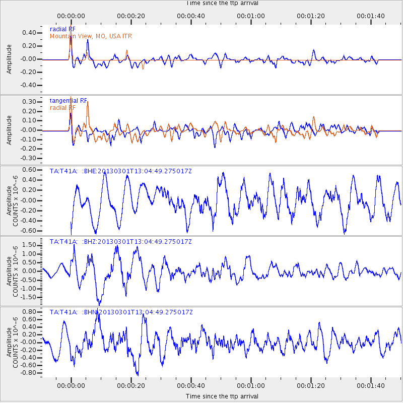
T41A Mountain View, MO, USA - Earthquake Result Viewer
*The percent match for this event was below the threshold and hence no stack was calculated.
| Earthquake location: |
Kuril Islands |
| Earthquake latitude/longitude: |
50.9/157.5 |
| Earthquake time(UTC): |
2013/03/01 (060) 12:53:51 GMT |
| Earthquake Depth: |
33 km |
| Earthquake Magnitude: |
5.7 MB, 5.8 MS, 6.4 MW, 6.4 MW |
| Earthquake Catalog/Contributor: |
WHDF/NEIC |
|
| Network: |
TA USArray Transportable Network (new EarthScope stations) |
| Station: |
T41A Mountain View, MO, USA |
| Lat/Lon: |
37.04 N/91.76 W |
| Elevation: |
366 m |
|
| Distance: |
73.5 deg |
| Az: |
51.286 deg |
| Baz: |
321.86 deg |
| Ray Param: |
$rayparam |
*The percent match for this event was below the threshold and hence was not used in the summary stack. |
|
| Radial Match: |
64.75709 % |
| Radial Bump: |
400 |
| Transverse Match: |
58.712955 % |
| Transverse Bump: |
400 |
| SOD ConfigId: |
494114 |
| Insert Time: |
2013-05-15 06:14:14.993 +0000 |
| GWidth: |
2.5 |
| Max Bumps: |
400 |
| Tol: |
0.001 |
|
Signal To Noise
| Channel | StoN | STA | LTA |
| TA:T41A: :BHZ:20130301T13:04:49.275017Z | 2.1924975 | 6.4207336E-7 | 2.9285022E-7 |
| TA:T41A: :BHN:20130301T13:04:49.275017Z | 1.0931505 | 2.729939E-7 | 2.497313E-7 |
| TA:T41A: :BHE:20130301T13:04:49.275017Z | 0.5702027 | 1.7806263E-7 | 3.1227955E-7 |
| Arrivals |
| Ps | |
| PpPs | |
| PsPs/PpSs | |


