You are here: Home > Network List > TA - USArray Transportable Network (new EarthScope stations) Stations List
> Station U44A Portageville, MO, USA > Earthquake Result Viewer
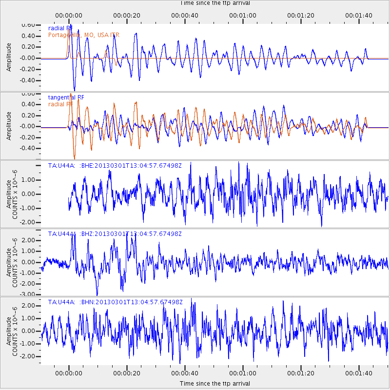
U44A Portageville, MO, USA - Earthquake Result Viewer
*The percent match for this event was below the threshold and hence no stack was calculated.
| Earthquake location: |
Kuril Islands |
| Earthquake latitude/longitude: |
50.9/157.5 |
| Earthquake time(UTC): |
2013/03/01 (060) 12:53:51 GMT |
| Earthquake Depth: |
33 km |
| Earthquake Magnitude: |
5.7 MB, 5.8 MS, 6.4 MW, 6.4 MW |
| Earthquake Catalog/Contributor: |
WHDF/NEIC |
|
| Network: |
TA USArray Transportable Network (new EarthScope stations) |
| Station: |
U44A Portageville, MO, USA |
| Lat/Lon: |
36.50 N/89.69 W |
| Elevation: |
89 m |
|
| Distance: |
74.9 deg |
| Az: |
50.256 deg |
| Baz: |
322.817 deg |
| Ray Param: |
$rayparam |
*The percent match for this event was below the threshold and hence was not used in the summary stack. |
|
| Radial Match: |
73.53758 % |
| Radial Bump: |
400 |
| Transverse Match: |
63.226482 % |
| Transverse Bump: |
400 |
| SOD ConfigId: |
494114 |
| Insert Time: |
2013-05-15 06:17:02.225 +0000 |
| GWidth: |
2.5 |
| Max Bumps: |
400 |
| Tol: |
0.001 |
|
Signal To Noise
| Channel | StoN | STA | LTA |
| TA:U44A: :BHZ:20130301T13:04:57.67498Z | 4.224673 | 1.0916921E-6 | 2.5840865E-7 |
| TA:U44A: :BHN:20130301T13:04:57.67498Z | 1.1349438 | 8.285504E-7 | 7.300365E-7 |
| TA:U44A: :BHE:20130301T13:04:57.67498Z | 0.9300835 | 5.94799E-7 | 6.3951137E-7 |
| Arrivals |
| Ps | |
| PpPs | |
| PsPs/PpSs | |


