You are here: Home > Network List > AV - Alaska Volcano Observatory Stations List
> Station MAPS Pakushin Southeast, Makushin Volcano, Alaska > Earthquake Result Viewer
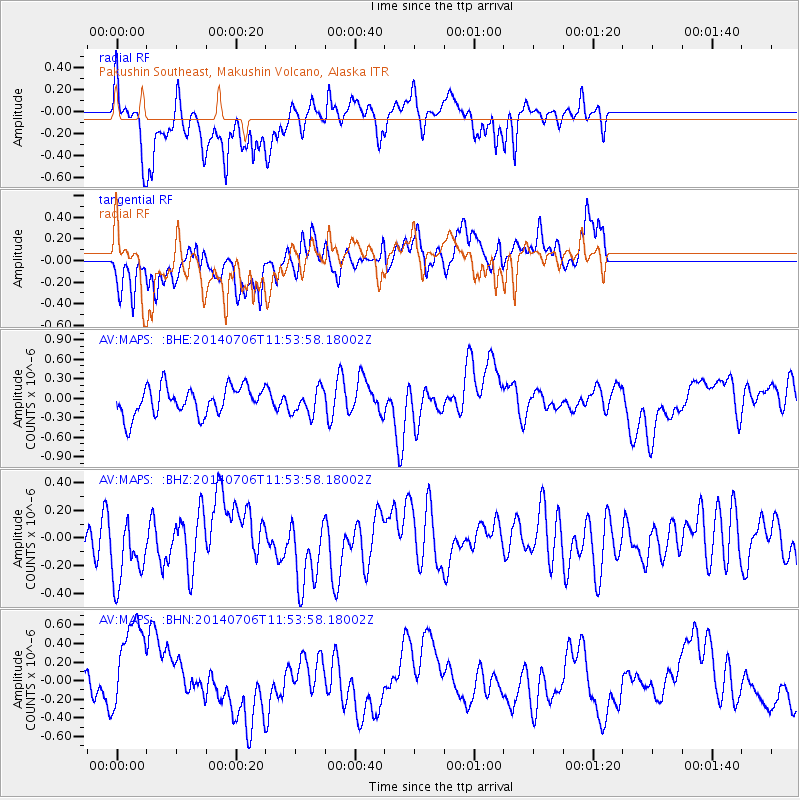
MAPS Pakushin Southeast, Makushin Volcano, Alaska - Earthquake Result Viewer
*The percent match for this event was below the threshold and hence no stack was calculated.
| Earthquake location: |
Costa Rica |
| Earthquake latitude/longitude: |
10.4/-85.3 |
| Earthquake time(UTC): |
2014/07/06 (187) 11:42:41 GMT |
| Earthquake Depth: |
35 km |
| Earthquake Magnitude: |
5.1 MW, 4.5 mb, 4.7 mb1, 4.4 mb1mx, 4.7 mbtmp, 3.5 ML, 3.9 MS, 3.9 Ms1, 3.8 ms1mx |
| Earthquake Catalog/Contributor: |
ISC/ISC |
|
| Network: |
AV Alaska Volcano Observatory |
| Station: |
MAPS Pakushin Southeast, Makushin Volcano, Alaska |
| Lat/Lon: |
53.81 N/166.94 W |
| Elevation: |
333 m |
|
| Distance: |
76.7 deg |
| Az: |
322.923 deg |
| Baz: |
90.53 deg |
| Ray Param: |
$rayparam |
*The percent match for this event was below the threshold and hence was not used in the summary stack. |
|
| Radial Match: |
62.107357 % |
| Radial Bump: |
372 |
| Transverse Match: |
52.085457 % |
| Transverse Bump: |
400 |
| SOD ConfigId: |
3390531 |
| Insert Time: |
2019-04-12 17:27:51.096 +0000 |
| GWidth: |
2.5 |
| Max Bumps: |
400 |
| Tol: |
0.001 |
|
Signal To Noise
| Channel | StoN | STA | LTA |
| AV:MAPS: :BHZ:20140706T11:53:58.18002Z | 1.478958 | 2.4452237E-7 | 1.6533423E-7 |
| AV:MAPS: :BHN:20140706T11:53:58.18002Z | 3.5406876 | 5.8506123E-7 | 1.6523943E-7 |
| AV:MAPS: :BHE:20140706T11:53:58.18002Z | 0.8963921 | 1.9745134E-7 | 2.202734E-7 |
| Arrivals |
| Ps | |
| PpPs | |
| PsPs/PpSs | |


