You are here: Home > Network List > TA - USArray Transportable Network (new EarthScope stations) Stations List
> Station N46A Monticello, IN, USA > Earthquake Result Viewer
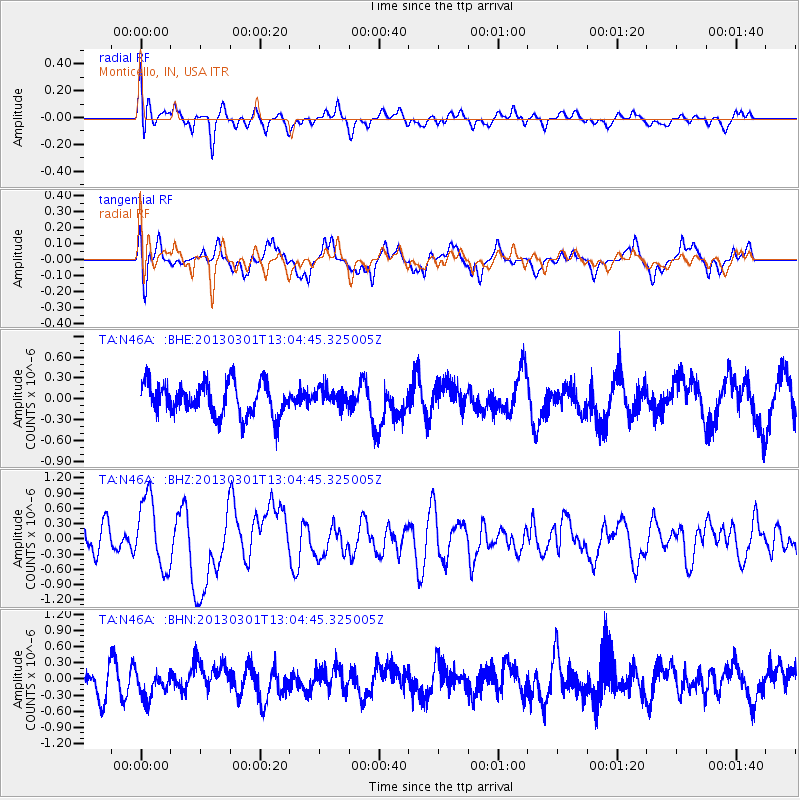
N46A Monticello, IN, USA - Earthquake Result Viewer
*The percent match for this event was below the threshold and hence no stack was calculated.
| Earthquake location: |
Kuril Islands |
| Earthquake latitude/longitude: |
50.9/157.5 |
| Earthquake time(UTC): |
2013/03/01 (060) 12:53:51 GMT |
| Earthquake Depth: |
33 km |
| Earthquake Magnitude: |
5.7 MB, 5.8 MS, 6.4 MW, 6.4 MW |
| Earthquake Catalog/Contributor: |
WHDF/NEIC |
|
| Network: |
TA USArray Transportable Network (new EarthScope stations) |
| Station: |
N46A Monticello, IN, USA |
| Lat/Lon: |
40.89 N/86.74 W |
| Elevation: |
209 m |
|
| Distance: |
72.8 deg |
| Az: |
45.593 deg |
| Baz: |
323.36 deg |
| Ray Param: |
$rayparam |
*The percent match for this event was below the threshold and hence was not used in the summary stack. |
|
| Radial Match: |
66.99873 % |
| Radial Bump: |
400 |
| Transverse Match: |
63.239475 % |
| Transverse Bump: |
400 |
| SOD ConfigId: |
494114 |
| Insert Time: |
2013-05-15 06:21:23.854 +0000 |
| GWidth: |
2.5 |
| Max Bumps: |
400 |
| Tol: |
0.001 |
|
Signal To Noise
| Channel | StoN | STA | LTA |
| TA:N46A: :BHZ:20130301T13:04:45.325005Z | 2.5594807 | 6.8498537E-7 | 2.676267E-7 |
| TA:N46A: :BHN:20130301T13:04:45.325005Z | 0.9293983 | 2.545942E-7 | 2.7393443E-7 |
| TA:N46A: :BHE:20130301T13:04:45.325005Z | 0.5610982 | 1.3202853E-7 | 2.353038E-7 |
| Arrivals |
| Ps | |
| PpPs | |
| PsPs/PpSs | |


