You are here: Home > Network List > TA - USArray Transportable Network (new EarthScope stations) Stations List
> Station N44A Piper City, IL, USA > Earthquake Result Viewer
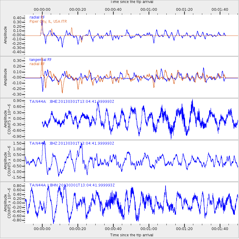
N44A Piper City, IL, USA - Earthquake Result Viewer
*The percent match for this event was below the threshold and hence no stack was calculated.
| Earthquake location: |
Kuril Islands |
| Earthquake latitude/longitude: |
50.9/157.5 |
| Earthquake time(UTC): |
2013/03/01 (060) 12:53:51 GMT |
| Earthquake Depth: |
33 km |
| Earthquake Magnitude: |
5.7 MB, 5.8 MS, 6.4 MW, 6.4 MW |
| Earthquake Catalog/Contributor: |
WHDF/NEIC |
|
| Network: |
TA USArray Transportable Network (new EarthScope stations) |
| Station: |
N44A Piper City, IL, USA |
| Lat/Lon: |
40.80 N/88.13 W |
| Elevation: |
202 m |
|
| Distance: |
72.2 deg |
| Az: |
46.545 deg |
| Baz: |
322.734 deg |
| Ray Param: |
$rayparam |
*The percent match for this event was below the threshold and hence was not used in the summary stack. |
|
| Radial Match: |
59.07397 % |
| Radial Bump: |
343 |
| Transverse Match: |
39.50697 % |
| Transverse Bump: |
366 |
| SOD ConfigId: |
494114 |
| Insert Time: |
2013-05-15 06:21:34.285 +0000 |
| GWidth: |
2.5 |
| Max Bumps: |
400 |
| Tol: |
0.001 |
|
Signal To Noise
| Channel | StoN | STA | LTA |
| TA:N44A: :BHZ:20130301T13:04:41.999993Z | 3.711327 | 9.649577E-7 | 2.600034E-7 |
| TA:N44A: :BHN:20130301T13:04:41.999993Z | 1.3465619 | 3.807403E-7 | 2.8274994E-7 |
| TA:N44A: :BHE:20130301T13:04:41.999993Z | 1.8742807 | 3.8685204E-7 | 2.0640027E-7 |
| Arrivals |
| Ps | |
| PpPs | |
| PsPs/PpSs | |


