You are here: Home > Network List > TA - USArray Transportable Network (new EarthScope stations) Stations List
> Station 151A Opelika, AL, USA > Earthquake Result Viewer
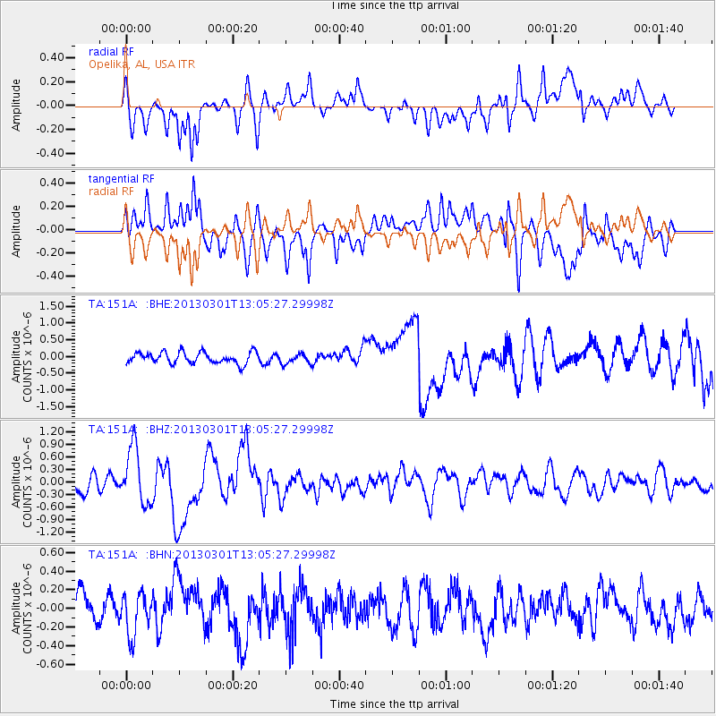
151A Opelika, AL, USA - Earthquake Result Viewer
*The percent match for this event was below the threshold and hence no stack was calculated.
| Earthquake location: |
Kuril Islands |
| Earthquake latitude/longitude: |
50.9/157.5 |
| Earthquake time(UTC): |
2013/03/01 (060) 12:53:51 GMT |
| Earthquake Depth: |
33 km |
| Earthquake Magnitude: |
5.7 MB, 5.8 MS, 6.4 MW, 6.4 MW |
| Earthquake Catalog/Contributor: |
WHDF/NEIC |
|
| Network: |
TA USArray Transportable Network (new EarthScope stations) |
| Station: |
151A Opelika, AL, USA |
| Lat/Lon: |
32.53 N/85.33 W |
| Elevation: |
211 m |
|
| Distance: |
80.2 deg |
| Az: |
49.662 deg |
| Baz: |
325.151 deg |
| Ray Param: |
$rayparam |
*The percent match for this event was below the threshold and hence was not used in the summary stack. |
|
| Radial Match: |
76.88049 % |
| Radial Bump: |
400 |
| Transverse Match: |
70.38462 % |
| Transverse Bump: |
400 |
| SOD ConfigId: |
494114 |
| Insert Time: |
2013-05-15 06:25:20.905 +0000 |
| GWidth: |
2.5 |
| Max Bumps: |
400 |
| Tol: |
0.001 |
|
Signal To Noise
| Channel | StoN | STA | LTA |
| TA:151A: :BHZ:20130301T13:05:27.29998Z | 2.6866846 | 6.8248505E-7 | 2.54025E-7 |
| TA:151A: :BHN:20130301T13:05:27.29998Z | 1.3438275 | 2.2005877E-7 | 1.6375522E-7 |
| TA:151A: :BHE:20130301T13:05:27.29998Z | 0.9143749 | 1.5438579E-7 | 1.68843E-7 |
| Arrivals |
| Ps | |
| PpPs | |
| PsPs/PpSs | |


