You are here: Home > Network List > TA - USArray Transportable Network (new EarthScope stations) Stations List
> Station 252A Lumpkin, GA, USA > Earthquake Result Viewer
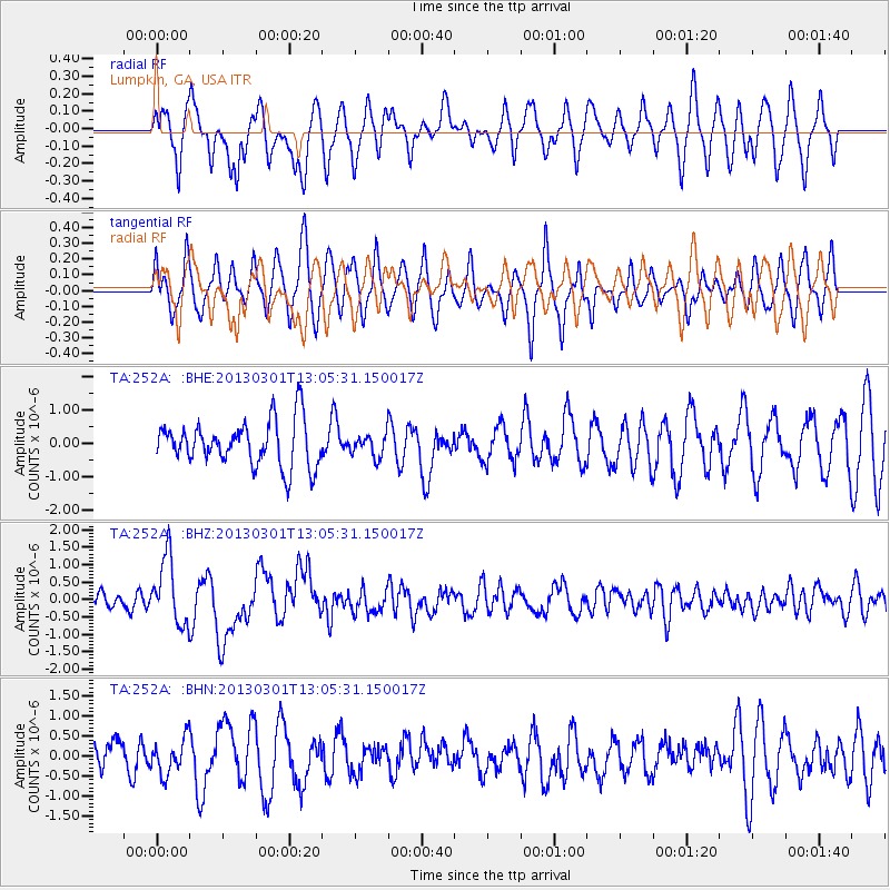
252A Lumpkin, GA, USA - Earthquake Result Viewer
*The percent match for this event was below the threshold and hence no stack was calculated.
| Earthquake location: |
Kuril Islands |
| Earthquake latitude/longitude: |
50.9/157.5 |
| Earthquake time(UTC): |
2013/03/01 (060) 12:53:51 GMT |
| Earthquake Depth: |
33 km |
| Earthquake Magnitude: |
5.7 MB, 5.8 MS, 6.4 MW, 6.4 MW |
| Earthquake Catalog/Contributor: |
WHDF/NEIC |
|
| Network: |
TA USArray Transportable Network (new EarthScope stations) |
| Station: |
252A Lumpkin, GA, USA |
| Lat/Lon: |
32.00 N/84.74 W |
| Elevation: |
142 m |
|
| Distance: |
81.0 deg |
| Az: |
49.55 deg |
| Baz: |
325.446 deg |
| Ray Param: |
$rayparam |
*The percent match for this event was below the threshold and hence was not used in the summary stack. |
|
| Radial Match: |
60.85996 % |
| Radial Bump: |
400 |
| Transverse Match: |
66.14679 % |
| Transverse Bump: |
380 |
| SOD ConfigId: |
494114 |
| Insert Time: |
2013-05-15 06:28:13.206 +0000 |
| GWidth: |
2.5 |
| Max Bumps: |
400 |
| Tol: |
0.001 |
|
Signal To Noise
| Channel | StoN | STA | LTA |
| TA:252A: :BHZ:20130301T13:05:31.150017Z | 3.4127376 | 9.494215E-7 | 2.781994E-7 |
| TA:252A: :BHN:20130301T13:05:31.150017Z | 0.68089366 | 4.4575373E-7 | 6.546598E-7 |
| TA:252A: :BHE:20130301T13:05:31.150017Z | 0.48404935 | 3.2412666E-7 | 6.696149E-7 |
| Arrivals |
| Ps | |
| PpPs | |
| PsPs/PpSs | |


