You are here: Home > Network List > TA - USArray Transportable Network (new EarthScope stations) Stations List
> Station V53A Saluda, NC, USA > Earthquake Result Viewer
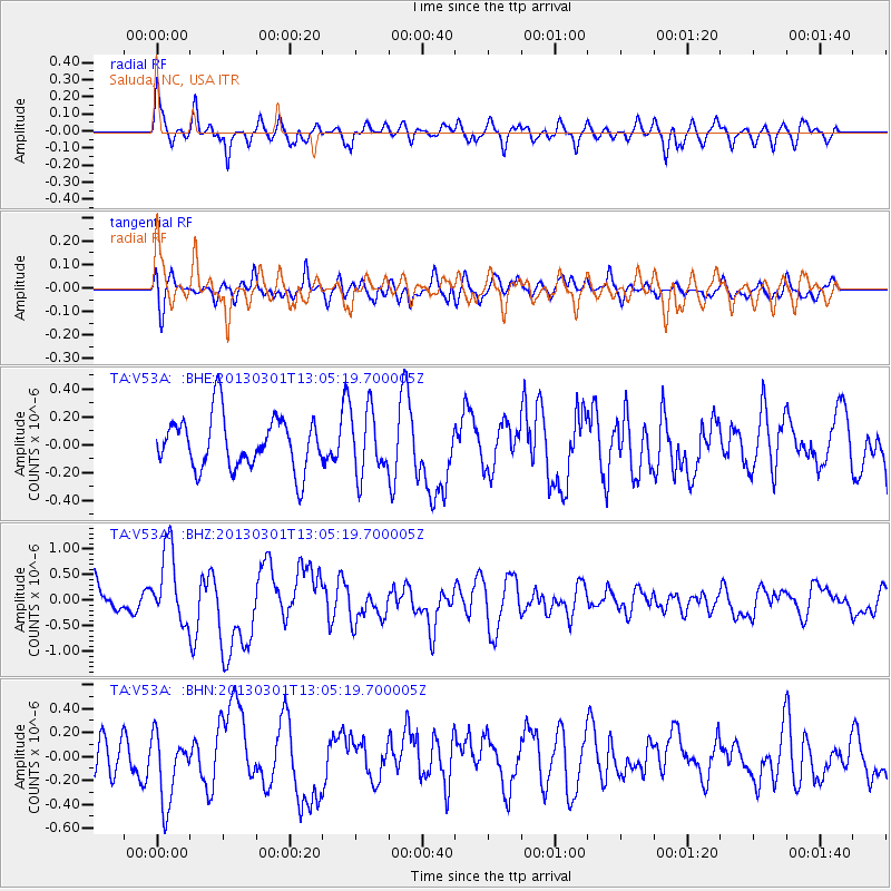
V53A Saluda, NC, USA - Earthquake Result Viewer
*The percent match for this event was below the threshold and hence no stack was calculated.
| Earthquake location: |
Kuril Islands |
| Earthquake latitude/longitude: |
50.9/157.5 |
| Earthquake time(UTC): |
2013/03/01 (060) 12:53:51 GMT |
| Earthquake Depth: |
33 km |
| Earthquake Magnitude: |
5.7 MB, 5.8 MS, 6.4 MW, 6.4 MW |
| Earthquake Catalog/Contributor: |
WHDF/NEIC |
|
| Network: |
TA USArray Transportable Network (new EarthScope stations) |
| Station: |
V53A Saluda, NC, USA |
| Lat/Lon: |
35.67 N/82.81 W |
| Elevation: |
681 m |
|
| Distance: |
78.8 deg |
| Az: |
46.109 deg |
| Baz: |
325.909 deg |
| Ray Param: |
$rayparam |
*The percent match for this event was below the threshold and hence was not used in the summary stack. |
|
| Radial Match: |
73.377205 % |
| Radial Bump: |
400 |
| Transverse Match: |
54.86184 % |
| Transverse Bump: |
400 |
| SOD ConfigId: |
494114 |
| Insert Time: |
2013-05-15 06:30:36.216 +0000 |
| GWidth: |
2.5 |
| Max Bumps: |
400 |
| Tol: |
0.001 |
|
Signal To Noise
| Channel | StoN | STA | LTA |
| TA:V53A: :BHZ:20130301T13:05:19.700005Z | 2.8513012 | 7.2330903E-7 | 2.5367683E-7 |
| TA:V53A: :BHN:20130301T13:05:19.700005Z | 1.9293406 | 2.9316126E-7 | 1.5194895E-7 |
| TA:V53A: :BHE:20130301T13:05:19.700005Z | 1.2249979 | 2.3035848E-7 | 1.8804808E-7 |
| Arrivals |
| Ps | |
| PpPs | |
| PsPs/PpSs | |


