You are here: Home > Network List > TA - USArray Transportable Network (new EarthScope stations) Stations List
> Station F49A Sandfield, ON, CAN > Earthquake Result Viewer
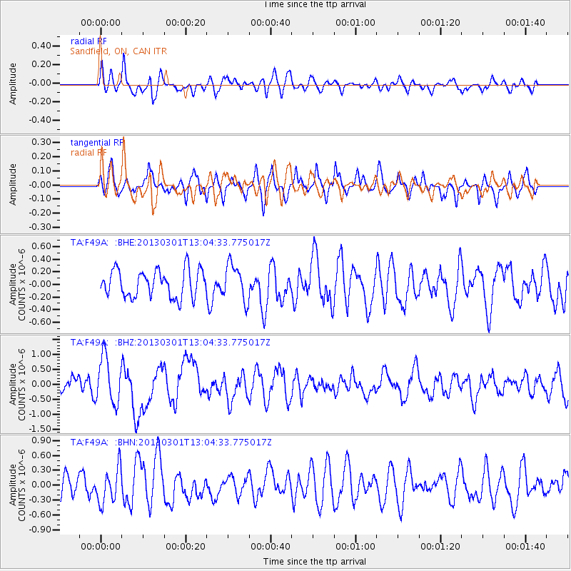
F49A Sandfield, ON, CAN - Earthquake Result Viewer
*The percent match for this event was below the threshold and hence no stack was calculated.
| Earthquake location: |
Kuril Islands |
| Earthquake latitude/longitude: |
50.9/157.5 |
| Earthquake time(UTC): |
2013/03/01 (060) 12:53:51 GMT |
| Earthquake Depth: |
33 km |
| Earthquake Magnitude: |
5.7 MB, 5.8 MS, 6.4 MW, 6.4 MW |
| Earthquake Catalog/Contributor: |
WHDF/NEIC |
|
| Network: |
TA USArray Transportable Network (new EarthScope stations) |
| Station: |
F49A Sandfield, ON, CAN |
| Lat/Lon: |
45.76 N/82.04 W |
| Elevation: |
230 m |
|
| Distance: |
70.9 deg |
| Az: |
39.671 deg |
| Baz: |
324.724 deg |
| Ray Param: |
$rayparam |
*The percent match for this event was below the threshold and hence was not used in the summary stack. |
|
| Radial Match: |
52.33258 % |
| Radial Bump: |
400 |
| Transverse Match: |
77.261734 % |
| Transverse Bump: |
400 |
| SOD ConfigId: |
494114 |
| Insert Time: |
2013-05-15 06:36:57.531 +0000 |
| GWidth: |
2.5 |
| Max Bumps: |
400 |
| Tol: |
0.001 |
|
Signal To Noise
| Channel | StoN | STA | LTA |
| TA:F49A: :BHZ:20130301T13:04:33.775017Z | 2.9124806 | 7.8130034E-7 | 2.682594E-7 |
| TA:F49A: :BHN:20130301T13:04:33.775017Z | 1.5453783 | 3.6218321E-7 | 2.3436539E-7 |
| TA:F49A: :BHE:20130301T13:04:33.775017Z | 1.3683786 | 2.9538393E-7 | 2.1586418E-7 |
| Arrivals |
| Ps | |
| PpPs | |
| PsPs/PpSs | |


