You are here: Home > Network List > TA - USArray Transportable Network (new EarthScope stations) Stations List
> Station G47A Hillman, MI, USA > Earthquake Result Viewer
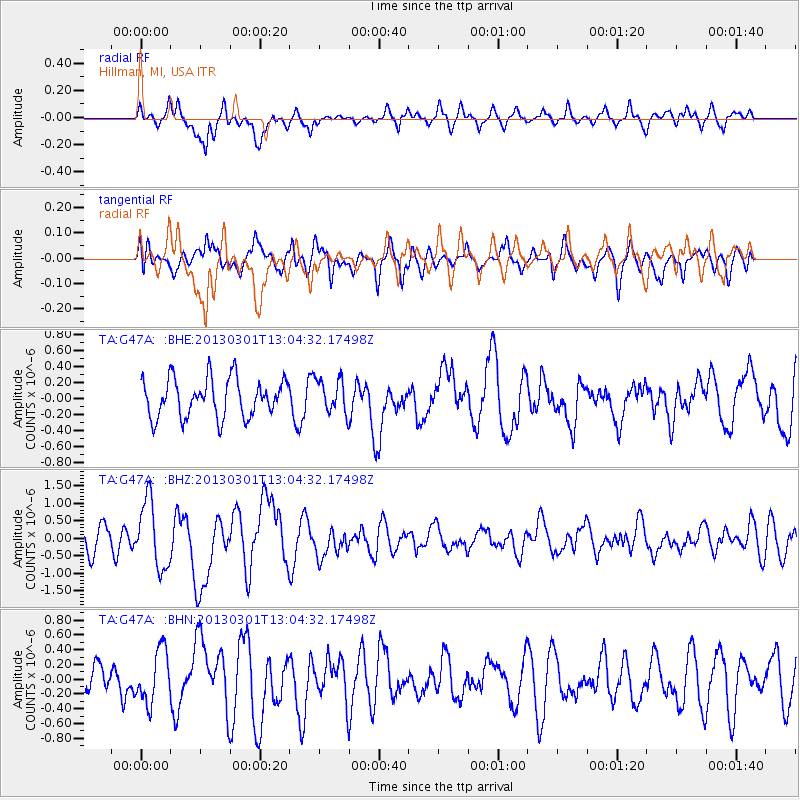
G47A Hillman, MI, USA - Earthquake Result Viewer
*The percent match for this event was below the threshold and hence no stack was calculated.
| Earthquake location: |
Kuril Islands |
| Earthquake latitude/longitude: |
50.9/157.5 |
| Earthquake time(UTC): |
2013/03/01 (060) 12:53:51 GMT |
| Earthquake Depth: |
33 km |
| Earthquake Magnitude: |
5.7 MB, 5.8 MS, 6.4 MW, 6.4 MW |
| Earthquake Catalog/Contributor: |
WHDF/NEIC |
|
| Network: |
TA USArray Transportable Network (new EarthScope stations) |
| Station: |
G47A Hillman, MI, USA |
| Lat/Lon: |
45.17 N/83.86 W |
| Elevation: |
239 m |
|
| Distance: |
70.6 deg |
| Az: |
41.133 deg |
| Baz: |
323.918 deg |
| Ray Param: |
$rayparam |
*The percent match for this event was below the threshold and hence was not used in the summary stack. |
|
| Radial Match: |
68.20404 % |
| Radial Bump: |
400 |
| Transverse Match: |
62.66371 % |
| Transverse Bump: |
400 |
| SOD ConfigId: |
494114 |
| Insert Time: |
2013-05-15 06:37:08.470 +0000 |
| GWidth: |
2.5 |
| Max Bumps: |
400 |
| Tol: |
0.001 |
|
Signal To Noise
| Channel | StoN | STA | LTA |
| TA:G47A: :BHZ:20130301T13:04:32.17498Z | 2.607275 | 9.55656E-7 | 3.665344E-7 |
| TA:G47A: :BHN:20130301T13:04:32.17498Z | 1.4606506 | 3.623217E-7 | 2.4805504E-7 |
| TA:G47A: :BHE:20130301T13:04:32.17498Z | 0.8752643 | 2.1041873E-7 | 2.4040594E-7 |
| Arrivals |
| Ps | |
| PpPs | |
| PsPs/PpSs | |


