You are here: Home > Network List > TA - USArray Transportable Network (new EarthScope stations) Stations List
> Station T54A Tazewell, VA, USA > Earthquake Result Viewer
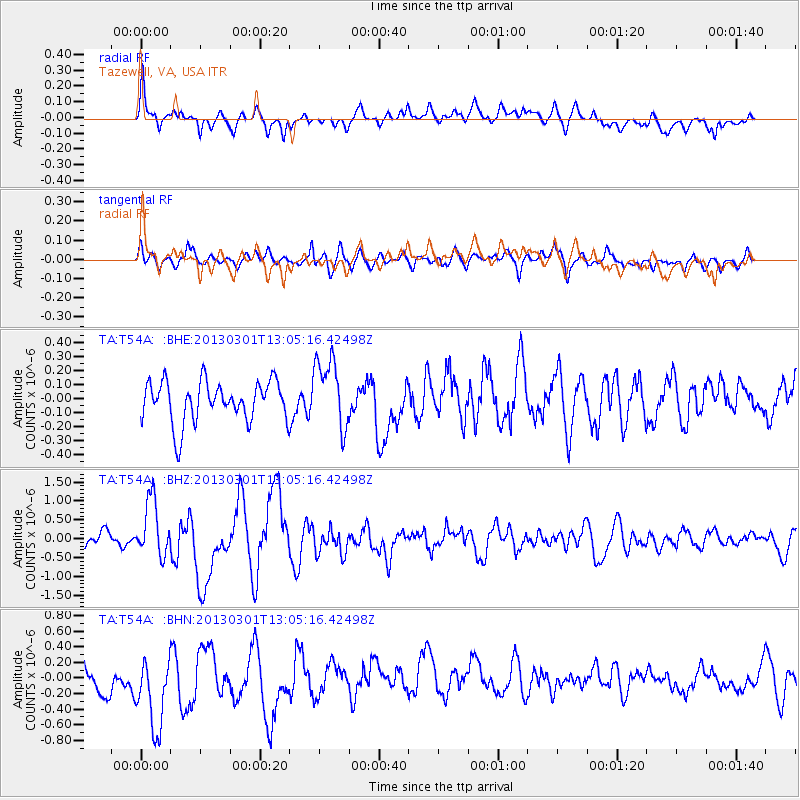
T54A Tazewell, VA, USA - Earthquake Result Viewer
*The percent match for this event was below the threshold and hence no stack was calculated.
| Earthquake location: |
Kuril Islands |
| Earthquake latitude/longitude: |
50.9/157.5 |
| Earthquake time(UTC): |
2013/03/01 (060) 12:53:51 GMT |
| Earthquake Depth: |
33 km |
| Earthquake Magnitude: |
5.7 MB, 5.8 MS, 6.4 MW, 6.4 MW |
| Earthquake Catalog/Contributor: |
WHDF/NEIC |
|
| Network: |
TA USArray Transportable Network (new EarthScope stations) |
| Station: |
T54A Tazewell, VA, USA |
| Lat/Lon: |
37.06 N/81.58 W |
| Elevation: |
852 m |
|
| Distance: |
78.2 deg |
| Az: |
44.474 deg |
| Baz: |
326.314 deg |
| Ray Param: |
$rayparam |
*The percent match for this event was below the threshold and hence was not used in the summary stack. |
|
| Radial Match: |
56.442696 % |
| Radial Bump: |
400 |
| Transverse Match: |
52.56228 % |
| Transverse Bump: |
400 |
| SOD ConfigId: |
494114 |
| Insert Time: |
2013-05-15 06:39:08.025 +0000 |
| GWidth: |
2.5 |
| Max Bumps: |
400 |
| Tol: |
0.001 |
|
Signal To Noise
| Channel | StoN | STA | LTA |
| TA:T54A: :BHZ:20130301T13:05:16.42498Z | 3.1688688 | 7.435744E-7 | 2.3464978E-7 |
| TA:T54A: :BHN:20130301T13:05:16.42498Z | 2.53751 | 5.967138E-7 | 2.3515722E-7 |
| TA:T54A: :BHE:20130301T13:05:16.42498Z | 1.7007927 | 2.486216E-7 | 1.4617984E-7 |
| Arrivals |
| Ps | |
| PpPs | |
| PsPs/PpSs | |


