You are here: Home > Network List > CI - Caltech Regional Seismic Network Stations List
> Station SWS Sam W. Stewart, Westmorland, CA, USA > Earthquake Result Viewer
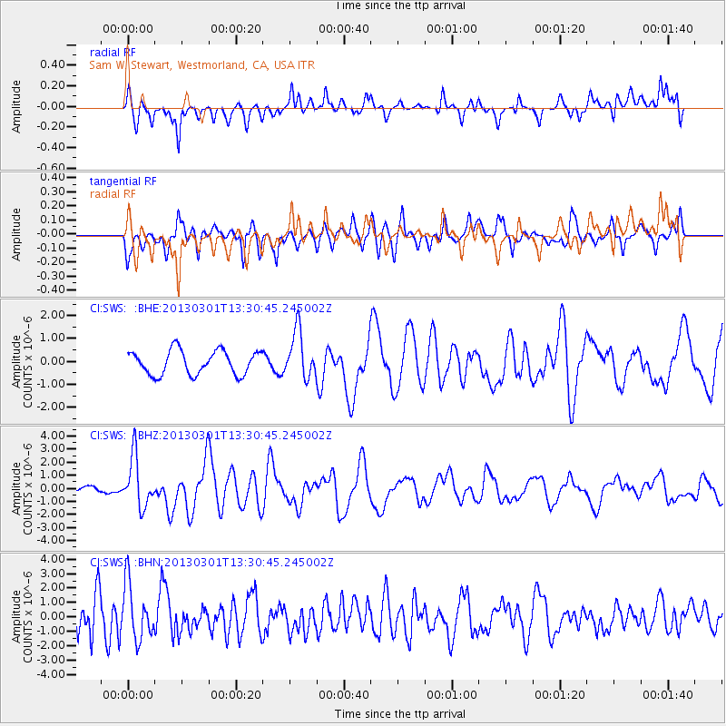
SWS Sam W. Stewart, Westmorland, CA, USA - Earthquake Result Viewer
*The percent match for this event was below the threshold and hence no stack was calculated.
| Earthquake location: |
Kuril Islands |
| Earthquake latitude/longitude: |
51.0/157.4 |
| Earthquake time(UTC): |
2013/03/01 (060) 13:20:49 GMT |
| Earthquake Depth: |
29 km |
| Earthquake Magnitude: |
6.3 MB, 6.3 MS, 6.5 MW, 6.4 MW |
| Earthquake Catalog/Contributor: |
WHDF/NEIC |
|
| Network: |
CI Caltech Regional Seismic Network |
| Station: |
SWS Sam W. Stewart, Westmorland, CA, USA |
| Lat/Lon: |
32.94 N/115.80 W |
| Elevation: |
140 m |
|
| Distance: |
63.3 deg |
| Az: |
69.982 deg |
| Baz: |
315.035 deg |
| Ray Param: |
$rayparam |
*The percent match for this event was below the threshold and hence was not used in the summary stack. |
|
| Radial Match: |
63.20327 % |
| Radial Bump: |
400 |
| Transverse Match: |
52.43389 % |
| Transverse Bump: |
337 |
| SOD ConfigId: |
494114 |
| Insert Time: |
2013-05-15 06:51:02.898 +0000 |
| GWidth: |
2.5 |
| Max Bumps: |
400 |
| Tol: |
0.001 |
|
Signal To Noise
| Channel | StoN | STA | LTA |
| CI:SWS: :BHZ:20130301T13:30:45.245002Z | 8.91663 | 1.9247418E-6 | 2.1585977E-7 |
| CI:SWS: :BHN:20130301T13:30:45.245002Z | 1.7948453 | 1.9338672E-6 | 1.0774561E-6 |
| CI:SWS: :BHE:20130301T13:30:45.245002Z | 1.9902513 | 1.0348391E-6 | 5.19954E-7 |
| Arrivals |
| Ps | |
| PpPs | |
| PsPs/PpSs | |


