You are here: Home > Network List > CI - Caltech Regional Seismic Network Stations List
> Station MPM Manuel Prospect Mine, California, USA > Earthquake Result Viewer
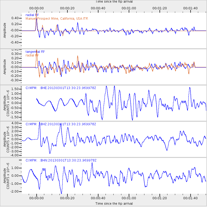
MPM Manuel Prospect Mine, California, USA - Earthquake Result Viewer
*The percent match for this event was below the threshold and hence no stack was calculated.
| Earthquake location: |
Kuril Islands |
| Earthquake latitude/longitude: |
51.0/157.4 |
| Earthquake time(UTC): |
2013/03/01 (060) 13:20:49 GMT |
| Earthquake Depth: |
29 km |
| Earthquake Magnitude: |
6.3 MB, 6.3 MS, 6.5 MW, 6.4 MW |
| Earthquake Catalog/Contributor: |
WHDF/NEIC |
|
| Network: |
CI Caltech Regional Seismic Network |
| Station: |
MPM Manuel Prospect Mine, California, USA |
| Lat/Lon: |
36.06 N/117.49 W |
| Elevation: |
185 m |
|
| Distance: |
60.2 deg |
| Az: |
68.56 deg |
| Baz: |
313.407 deg |
| Ray Param: |
$rayparam |
*The percent match for this event was below the threshold and hence was not used in the summary stack. |
|
| Radial Match: |
68.737755 % |
| Radial Bump: |
400 |
| Transverse Match: |
69.34584 % |
| Transverse Bump: |
400 |
| SOD ConfigId: |
494114 |
| Insert Time: |
2013-05-15 06:51:07.107 +0000 |
| GWidth: |
2.5 |
| Max Bumps: |
400 |
| Tol: |
0.001 |
|
Signal To Noise
| Channel | StoN | STA | LTA |
| CI:MPM: :BHZ:20130301T13:30:23.969978Z | 5.376651 | 1.6992E-6 | 3.1603318E-7 |
| CI:MPM: :BHN:20130301T13:30:23.969978Z | 1.8857951 | 7.8342026E-7 | 4.1543234E-7 |
| CI:MPM: :BHE:20130301T13:30:23.969978Z | 1.8948705 | 6.333044E-7 | 3.3422043E-7 |
| Arrivals |
| Ps | |
| PpPs | |
| PsPs/PpSs | |


