You are here: Home > Network List > CI - Caltech Regional Seismic Network Stations List
> Station VES Vestal, Richgrove, CA, USA > Earthquake Result Viewer
VES Vestal, Richgrove, CA, USA - Earthquake Result Viewer

| Earthquake location: |
Kuril Islands |
| Earthquake latitude/longitude: |
51.0/157.4 |
| Earthquake time(UTC): |
2013/03/01 (060) 13:20:49 GMT |
| Earthquake Depth: |
29 km |
| Earthquake Magnitude: |
6.3 MB, 6.3 MS, 6.5 MW, 6.4 MW |
| Earthquake Catalog/Contributor: |
WHDF/NEIC |
|
| Network: |
CI Caltech Regional Seismic Network |
| Station: |
VES Vestal, Richgrove, CA, USA |
| Lat/Lon: |
35.84 N/119.08 W |
| Elevation: |
154 m |
|
| Distance: |
59.4 deg |
| Az: |
69.77 deg |
| Baz: |
313.083 deg |
| Ray Param: |
0.062194053 |
| Estimated Moho Depth: |
28.0 km |
| Estimated Crust Vp/Vs: |
2.07 |
| Assumed Crust Vp: |
6.1 km/s |
| Estimated Crust Vs: |
2.954 km/s |
| Estimated Crust Poisson's Ratio: |
0.35 |
|
| Radial Match: |
84.90645 % |
| Radial Bump: |
376 |
| Transverse Match: |
79.34406 % |
| Transverse Bump: |
317 |
| SOD ConfigId: |
494114 |
| Insert Time: |
2013-05-15 06:51:55.417 +0000 |
| GWidth: |
2.5 |
| Max Bumps: |
400 |
| Tol: |
0.001 |
|
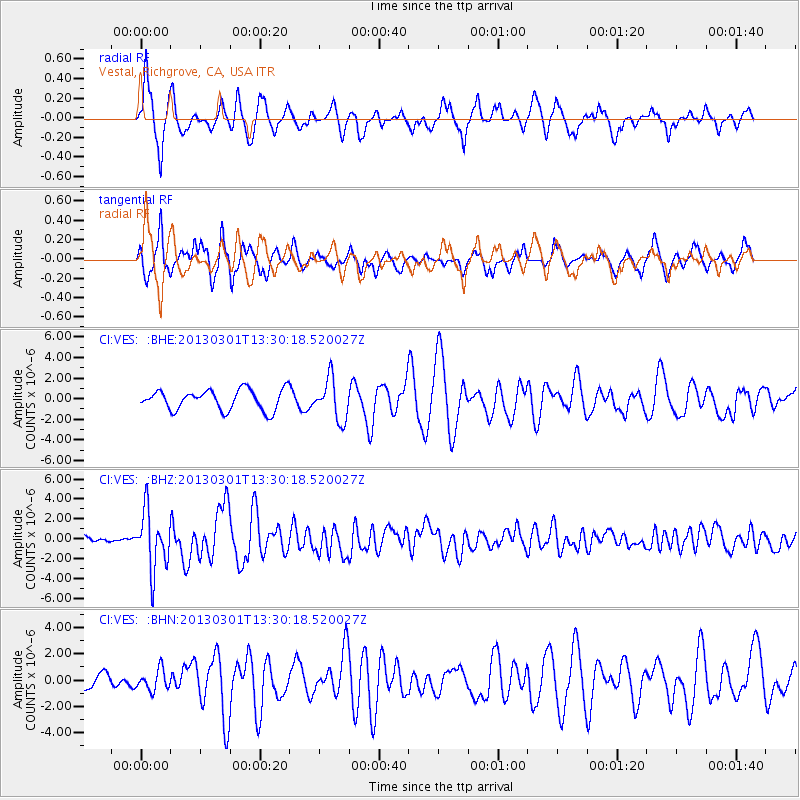
Signal To Noise
| Channel | StoN | STA | LTA |
| CI:VES: :BHZ:20130301T13:30:18.520027Z | 6.479388 | 2.918121E-6 | 4.5036984E-7 |
| CI:VES: :BHN:20130301T13:30:18.520027Z | 0.8466913 | 7.9285996E-7 | 9.364215E-7 |
| CI:VES: :BHE:20130301T13:30:18.520027Z | 2.0053403 | 1.9758406E-6 | 9.852894E-7 |
| Arrivals |
| Ps | 5.1 SECOND |
| PpPs | 14 SECOND |
| PsPs/PpSs | 19 SECOND |


