You are here: Home > Network List > CI - Caltech Regional Seismic Network Stations List
> Station ADO Adelanto Receiving Station, Victorville, CA, USA > Earthquake Result Viewer
ADO Adelanto Receiving Station, Victorville, CA, USA - Earthquake Result Viewer

| Earthquake location: |
Kuril Islands |
| Earthquake latitude/longitude: |
51.0/157.4 |
| Earthquake time(UTC): |
2013/03/01 (060) 13:20:49 GMT |
| Earthquake Depth: |
29 km |
| Earthquake Magnitude: |
6.3 MB, 6.3 MS, 6.5 MW, 6.4 MW |
| Earthquake Catalog/Contributor: |
WHDF/NEIC |
|
| Network: |
CI Caltech Regional Seismic Network |
| Station: |
ADO Adelanto Receiving Station, Victorville, CA, USA |
| Lat/Lon: |
34.55 N/117.43 W |
| Elevation: |
908 m |
|
| Distance: |
61.2 deg |
| Az: |
69.771 deg |
| Baz: |
314.031 deg |
| Ray Param: |
0.06096594 |
| Estimated Moho Depth: |
11.25 km |
| Estimated Crust Vp/Vs: |
1.67 |
| Assumed Crust Vp: |
6.276 km/s |
| Estimated Crust Vs: |
3.752 km/s |
| Estimated Crust Poisson's Ratio: |
0.22 |
|
| Radial Match: |
90.071236 % |
| Radial Bump: |
400 |
| Transverse Match: |
78.64689 % |
| Transverse Bump: |
368 |
| SOD ConfigId: |
494114 |
| Insert Time: |
2013-05-15 06:52:16.249 +0000 |
| GWidth: |
2.5 |
| Max Bumps: |
400 |
| Tol: |
0.001 |
|
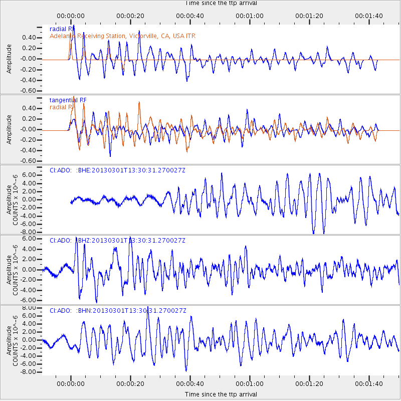
Signal To Noise
| Channel | StoN | STA | LTA |
| CI:ADO: :BHZ:20130301T13:30:31.270027Z | 8.2361965 | 3.2858622E-6 | 3.9895383E-7 |
| CI:ADO: :BHN:20130301T13:30:31.270027Z | 3.391028 | 2.4289113E-6 | 7.1627585E-7 |
| CI:ADO: :BHE:20130301T13:30:31.270027Z | 2.3390408 | 1.3848615E-6 | 5.920639E-7 |
| Arrivals |
| Ps | 1.3 SECOND |
| PpPs | 4.6 SECOND |
| PsPs/PpSs | 5.8 SECOND |


